|
|
|
|
|
|
|
|
|
The Cave Run Lake Trail Guide has over 90 miles of legendary Kentucky singletrack trail all mapped with Trimble GPS. At 1:18,000 scale and with 50-ft elevation contours and aerial photography, it is the most accurate guide for Cave Run. The guide has 8 maps that fit into a clear plastic bag. No more wrestling with a monster fold-out map! Pick your trail and then map, and finally hit it hard. Do you want
a free set of maps? DOWNLOADS
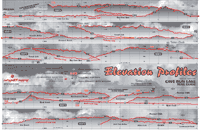 The Trail Guide contains printed Elevation Profiles Download your preview PDF! Page 1 (3 megs) | Page 2 (3 megs) |
![]()