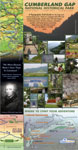
A
Topographic Trail Guide for the Gap and surrounding areas. Trails are
mapped with GPS and aerial photos. Guide shows 3D trail length,
2-km grid, 50-ft contours, elevation profiles, and backcountry
amenities. Maps show over 80 miles of trail at 1:32,000 & 1:14,000
scales. A
Topographic Trail Guide for the Gap and surrounding areas. Trails are
mapped with GPS and aerial photos. Guide shows 3D trail length,
2-km grid, 50-ft contours, elevation profiles, and backcountry
amenities. Maps show over 80 miles of trail at 1:32,000 & 1:14,000
scales.
Before
pioneer explorers crossed the Gap, Native Americans were using the
pass for millennia. Today, hikers can visit the same historic locations. |
 |
Custom Cartography, Custom Mapping, Kentucky, Daniel
Boone National Forest, Cave Run, Red River Gorge, Cumberland Gap, Hiking,
Mountain Biking, Sheltowee Trace, Trail Maps, Maps, Guides, Boyd Shearer,
Boyd Shearer Jr., Boyd Landerson Shearer Jr., Audio Driving Tours, Audio
Atlas, Topography, GPS, GIS, geographic infromation system