![]() NEW
OUTRAGEGIS MAPPING:
HOME | SAMPLES
| DOWNLOAD
| PHOTOS
| DISCUSS | SERIES
| PURCHASE
|
3D
NEW
OUTRAGEGIS MAPPING:
HOME | SAMPLES
| DOWNLOAD
| PHOTOS
| DISCUSS | SERIES
| PURCHASE
|
3D
|
|
5
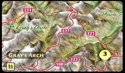
Detailed Maps - 5 Weekends What is in our maps? US Forest Service trails, rugged spur trails, outback campsites, & heavenly views all mapped with high-precision GPS. With elevation profiles & aerial photography, our maps show the most detailed, and numerous, hikes yet published for the Gorge. Visit one of the above links to explore the map series. Check back soon for more resources! |
Whether you buy one map or the complete series, you will own a finely honed tool for pleasurable navigation. Geological
Wonders & Trails |
outrageGIS's
welcome page
![]()
Last Updated on
April 19, 2005