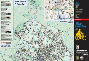
We are proud to announce the release of the Bike Lexington Map which locates bicycling facilities and preferred routes in Lexington, Kentucky. The purpose of the map is to show existing facilities (such as bike lanes and shared-use paths) and preferred routes (wider roads with low volume and/or low speed) Â to encourage cycling and help cyclists plan trips through the city.
This 27″ x 39″ free, full-color map can be found at local bicycling shops and the Bread Box’s Broke Spoke and West 6th Street Brewing. UK students can pick up the map at Wildcat Wheels. Other outlets are sure to be added.
Digital PDF copies are offered in a few versions.
- The official map (7 megabytes) is the version printed.
- A map with aerial photography (49 megabytes) shows the built environment and surrounding countryside.
- A map book (27 megabytes)Â allows for easier printing and mobile use.


Leave a Reply