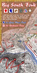
Topographic Trail Maps for the Big South Fork National River and Recreation Area. A guide for the adventurer, picture-taker, and nature lover. 6 maps in a durable, weatherproof pack for weekends of woodland romance.
Backcountry trails include the 45-mile John Muir Trail, the 45-mile southern terminus section of the Sheltowee Trace to US 27, the Kentucky Trail, Twin Arches Loop, Litton & Blevins Farm Loops, Pilot Wines & Big Island Equestrian Loops, Hidden Passage Loop, Rock Creek Loop, Leatherwood Ford Loop, Grand Gap Loop, Blue Heron Loop and trails around the Charit Creek Lodge area. Over 200 miles of trails mapped!
Scenic areas include Angel Falls Overlook, Sunset Overlook, O&W Bridge, Bronco Overlook, John Muir Overlook, Fall Branch, and No Business Creek.
|
 |
 |
|
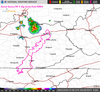
Weather
View current set of weather maps and forecasts for Gorge hikers. |
Current Conditions
Mostly Cloudy and 63 F at Monticello, Wayne County Airport
Winds are calm.
The pressure is 30.13.
Last Updated on Apr 30 2025, 4:56 am EDT.
Visible satellite 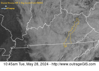 |
|
| BSF Trails & News
• National Land Cover Database on SheltoweeTrace.com
Two new layers have been added to the web map for the Daniel Boone NF and Big South Fork NRRA: the National Land Cover Database (NLCD) fo...
• Yahoo Falls
Yahoo Falls Picnic Area is located in the Big South Fork National River and Recreation Area in Kentucky. The scenic area contains short h...
• New base maps for Sheltowee Trace
Find high-resolution aerial imagery and shaded relief maps for Kentucky (and some for Tennessee) on SheltoweeTrace.com.
• Cumulative elevation gain calculator
How much elevation gain did you have on your last Sheltowee Trace hike? We built a calculator and elevation profile on SheltoweeTrace.com...
|
|
|
|

Explore a land of arches, waterfalls, and rustic river views. Visit historic homesteads & coal camps. Hike to a gorge rim overlook and survey the wonder that is the Big South Fork.
|
|
$12 - Buy 
Includes GPS mapped trails, aerial photography, 50-ft topo contours, spot elevations, UTM & GEO GPS grids, and a JMT trail elevation profile. 4-mil poly Zipper bag.
Samples |
This is what you get:
1:84,480 scale Overview Map. 6 spot-color, 18.5 x 13.5 inches. Shows all trails between O&W Bridge and Blue Heron with mile markers for the John Muir Trail and Sheltowee Trace.
1:31,640 scale Topo Maps. 5 spot-color, 18.5 x 13.5 inches, 2 Maps. Shows true mileage between intersections for all official trails. 50-ft elevation contours. Shows entire John Muir Trail and all intersecting trails.
3D Trail Map. Full-color, 18.5 x 13.5 in unique map showing trails, arches, waterfalls, and scenic destinaitons.
1:126,720 scale Recreation Map. 2-color, 18.5 x 13.5 map of all trails in Big South Fork area, including Pickett State Park, Stearns Ranger District in USFS, Rugby, and Darrow Ridge.
John Muir Trail Elevation Profile. 2-color, 11 x 17 poster showing the elevation profile of the JMT and small sections of important connecting trails.
Don't forget the online GPS Download. An online download that gives 1,000 waypoints, John Muir Trail track file, and trail elevation profile.

|
|