Home
Images of Maps
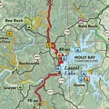
Laurel Lake
Photo sizes
XXS - tiny
(174 x 240)
XS - extra small
(236 x 324)
S - small
(314 x 432)
M - medium
(432 x 594)
L - large
(551 x 756)
Original
(656 x 900)
slideshow
Download this file
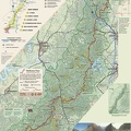
Trail map locates developed and primitive campgrounds. - Trail map locates developed and primitive campgrounds.
Information
Created on
Monday 15 June 2009
Posted on
Monday 15 June 2009
Visits
2840
Albums
Images of Maps
/
Samples of selected published maps
/
Sheltowee Trace Trail Map
Powered by
Piwigo
