| outrageGIS mapping ACCESS SITES WELCOME | |||||||
 (THIS MAP IS CLICKABLE) |
|||||||
"NOT JUST a guide for locating fishing and boating access sites, but a complete guide to all of the public recreation areas in the State of Kentucky. State Parks, Forests, Nature Preserves....you name it, this guide has it. " TO DOWNLOAD AND ENJOY ALL BENEFITS OF GUIDE YOU NEED ADOBE ACROBAT 3.0 PDF READER The numbers below correspond to the range of page numbers in the printed publication. The access sites are detailed by watershed. Each page has a clickable map to help navigate the various watersheds. Although this publication is provided as a free service, the PDF documents have been encrypted to prevent printing, selecting graphics within, or altering the document. If you need special services, then please contact us. NOTE: to get information on individual access sites, you must view the database in the downloadable PDF offered by watershed.
|
|||||||
|
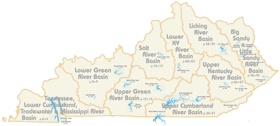
1 48 2-7 8-11 12-17 18-21 22-25 26-29 30-37 38-41 42-47 |
SECTION Basic information for using Guide Index of watersheds and basic Kentucky Map Lower Cumberland River Lower Green River Upper Green River Salt River Lower Kesntucky River Upper Kentucky River Upper Cumberland River Licking River Big Sandy and Little Sandy Rivers |
||||||
|
By using any portion of this website or PDF material, you agree to this Disclaimer. |
|||||||
|
outrageGIS home
|
|||||||