 Boyd started
  John operates and manages outrageGIS mapping's offset print studio. As a long-time manager of various print shops, he understands production from layout to pre-press to finishing. When he's not printing, he is chef and caterer extraordinaire.
If you visit this site often, you likely have a favorite map app on your phone. I certainly do and I have installed dozens of apps over the years. Most focus on placing your location as a dot on the map.
The dotAny map app that shows your location as a dot on the map fosters a dependence on your...

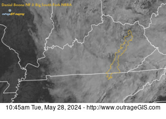 Check out our weather stations