
 Great Smokies Trail Atlas
Distance: 9 Miles round-trip from trailhead
Difficulty: +++
Scenic Views: +++
Elevation Relief: 1,800ft ^^
Ownership: Great Smoky Mountains, NPS
| Great Smokies Trail Atlas: $14 |
 |
As you drive from the Sugarlands Visitor Center on Newfound Gap Road, you’ll catch glimpses of the Chimney Tops, a summit outcropping of tough, erosion resistant metamorphic rock. Originally deposited as sedimentary rock, such as shale, sandstone, and siltstone over 500 million years ago, the rocks that make the mountains here first experienced metamorphosis becoming a hard, slate-type rock, and then mountain building forces to form the folded and faulted Appalachians, with peaks as high as the Rocky Mountains. Today, after 200 million years of erosion, Chimney Tops stands at 4,800 feet and roughly a 1,400 vertical foot climb from the trailhead below. As you walk and climb along the last quarter-mile of the ridge, you’ll clearly see the bedrock tilting down to the right, evidence of the great tectonic forces that thrust up the mountains that you’ll admire around you from this inspiring prominence.
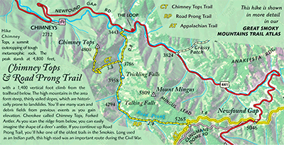
The name the Cherokee Indians gave Chimney Tops, was Forked Antler. As you scan the ridge from valley overlooks, you can easily imagine the shape of a deer’s antler. The first 3/4 mile of this hike follows Road Prong, a stream that reaches the crest line of the Smokies. If you continue up Road Prong trail, you’ll hike one of the oldest trails in the area. Long used as an Indian path through the mountains, the path was expanded during the Civil War to move troops through the Smokies connecting Smokemont, North Carolina with Gatlinburg, Tennessee. The road was called the Oconaluftee Turnpike and it passed through Indian Gap at the summit. Today the summit is marked with the Appalachian Trail and Indian Gap is called Luftee Gap.
A note about climate and slope in the mountains. The high mountains in the area form steep, thinly soiled slopes, which are historically prone to landslides after extended periods of heavy rain. You’ll see many scars and debris fields from previous landslides as you hike to the summit. And the Smokies know plenty about rain: the summit line receives on average more precipitation anywhere east of the U.S. mountain west coast.
Because of the elevation, the temperature is similar to Canada, but because of the relief (over a mile above surrounding foothills), the precipitation pattern is more typical marine, creating colder and wetter conditions. Because of the proximity to Gulf and Atlantic tropical air masses, summer storms, especially remnants of hurricanes, can produce torrential rain events. These storms increase flash flooding and landslide hazards. In the late winter, polar air masses from the north can create an upslope flow forcing up moisture rich air and produce heavy snowfall. With an average of 5-8 inches of rain per month, streams can be difficult to cross anytime of the year. Please contact the park service before any backcountry trip.


