 Winter storm warning, Dec 15-16, 2008.
“The National Weather Service will issue a winter storm warning when a dangerous combination of heavy snow, with sleet and/or freezing rain, will occur or has a high probability of occurring within the next 12 hours.”
Severe winter weather events are notorious to forecast. Our TV weathercasters had a range of predictions from a half-inch of ice accumulation to 5 inches of snow. The National Weather Service (NWS) had a similar forecast. After the event, we had a lot of variability across the region, so in part, all of the predictions were somewhere correct. I think the NWS made a good prediction on where the bad weather would happen, but the severity was hard to calculate.
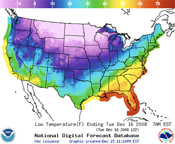
The above map (shown in greater detail below) shows low temperatures across the U.S. and highlights the problem with forecasting such a large storm. The huge temperature change from -20° F in the northern states to 60° F in the southeast indicates two vastly different air masses in close proximity. The greater the difference, the more difficult the predictions. When the air masses begin to interact and do their dance, that’s the problem.
It’s easy to forecast calm conditions, but when the weather becomes bad, the severity is determined by how different the air masses are and how much they interact. Two similar air masses doing a “big dance” will have little impact. Two vastly dissimilar air masses just interacting slightly will produce enormous weather. Though we can measure the characteristics of air masses, the problem is that we can’t predict how they’ll interact.
The basic setup we had here was that cold polar plunged southward, and displaced the warmer, more moist tropical air. As the warmer, less dense air rode over the advancing colder, denser air, precipitation fell as rain. As it traveled through the colder, ground layer of air, it froze on surface contact. That’s freezing rain. However when upper layer of air approaches the freezing point, precipitation could fall as snow or sleet. As this boundary zone between air masses changes, the vertical temperature profile changes and so does the type precipitation that hits the ground.
Can you feel it for the weathercaster trying to predict this stuff?
Watches and Warnings Map, Dec 16
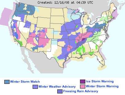
Above map is the Watches and Warnings for the U.S., December 16, 2008. Compare this map to the below map, which forecasts low temperatures for this morning. Note the axis of warnings from Texas to Pennsylvania which overlays a sharp temperature contrast between the polar air to the northwest and tropical air to the southeast. This steep temperature gradient is almost 90° F and is zone of interaction.
Low Temperature Map, Dec 16
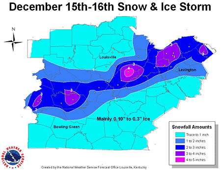
The below map shows snow and ice totals for the Bluegrass region.