
City of Rocks example visual
With the quality of elevation data increasing, especially with the availability of LiDAR data, we have an opportunity to make unique visuals. Recently Wolverine Publishing needed maps developed for the climbing area, City of Rocks in Idaho. The project needed high-resolution maps and the data was available through public sources. We like making the physiographic base maps for recreation areas and this offered a special challenge.
The client needed a realistic view of the area that accentuated the rock structure of the climbing areas. We used 1-meter resolution NAIP aerial photography, which we then used to create a vegetation layer via an NDVI analysis. LiDAR data was available and was used to create 1-meter resolution DEMs. Ultimately, a Photoshop file was produced for selected areas in City of Rocks National Reserve. The layering process is straight forward, but the files for each zone were about 1.5 GB.
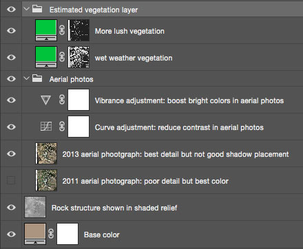
View the layering of the derived spatial data in Photoshop
The main challenge was processing all of this data into useful single layers to input Photoshop.
In my GIS course, we were doing something similar for state parks in Kentucky. This granted a teaching moment and brought the real-world into the classroom, as they say. We were making tools that made maps of any state park using data from Kentucky’s GIS geoportal and other public sources. The idea was to supply an Area of Interest polygon and let the tool process out layers to feed other applications. This is similar to the City of Rocks project; give a polygon of the desired area and kick out a single aerial photograph and elevation layers. This is bread and butter GIS I like to say.
We developed Python script using ArcGIS ArcPy package to process an assortment of feature class data and raster aerial photography and DEM layers. The goal was to create single layers that could feed a QGIS project for 3D mapping and uploading to CartoDB. We published the final script to Github repo:Â https://github.com/boydx/GEO409_L02.
Want to see more maps and visuals that this tool help build?
Castle Rock State Park 3D map (from QGIS and is 100 MB):Â http://boydx.github.io/CastleRockStatePark3DÂ or a single view made in ArcScene:Â http://boydx.github.io/CastleRockStatePark3D/3d_castle-rock-view.jpg
Greenbo Lake State Resort Park in CartoDB: http://boydx.github.io/Greenbo-Lake-Trail-Map and below is the 3D view of the park.
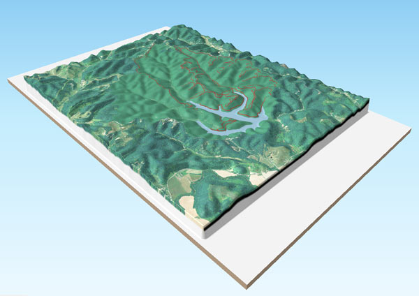
Example 3D map of Greenbo Lake State Resort Park


Speak Your Mind
You must be logged in to post a comment.