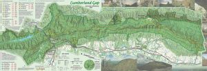
2016 Cumberland Gap trail map and hiking information
The update to our Cumberland Gap National Historical Park is now available. Much like the old map, our 2017 version is a 1 inch to 1/2 mile scale map with 50-foot contours, trail elevation profiles, and  GPS-mapped trails shown in vivid full-color printing. This year we added a layer that shows the density of canopy coverage and GPS-mapped Caldwell Gap Trail. The size of the park has increased since our last update, so we’ve included most of the additional land.
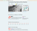
Gap weather page using Dark Sky weather data
Weather Station
We also have updated our weather page for the high mountain elevations for Cumberland Gap using hourly forecast information and time-lapse satellite photography. This will help plan your latest adventure to unique mountain environment of Cumberland Gap. You can find the weather station here: https://outrageGIS.com/weather/gap.
If you want to check out the map, please visit our booth this weekend (location and coordinates are shown on the below map). Find us on the Woodland Christian Church side of the fair at the shady bottom of the hill.
.
Cumberland Gap map details
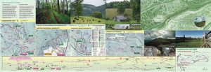
2017 Cumberland Gap trail map, legend and trail elevation
The map is two double-sided 19.5″ x 13.25″ full-color nicely printed pages. The map inset side has four maps of popular recreation destinations in the area with 2014 aerial photography as a base map. Elevation profiles now have all trails in the park shown. We’ve also updated our Bird’s Eye View map, with trails and overnight camps. We’re fleshing out the companion website with trail information and suggested trips in the Gap.
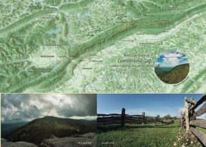
Detail of 2017 Cumberland Gap trail map, Bird’s Eye View
Our interactive maps show trails, trailheads, scenic views, and destinations with a companion guide that shares good backcountry hikes and notes about trail conditions. Our weather station for the park will help you plan your trip and understand mountain climate. Admire the ancient forces of nature as you hike along pioneer trails such as Boone’s Trace and the Wilderness Road.


Speak Your Mind
You must be logged in to post a comment.