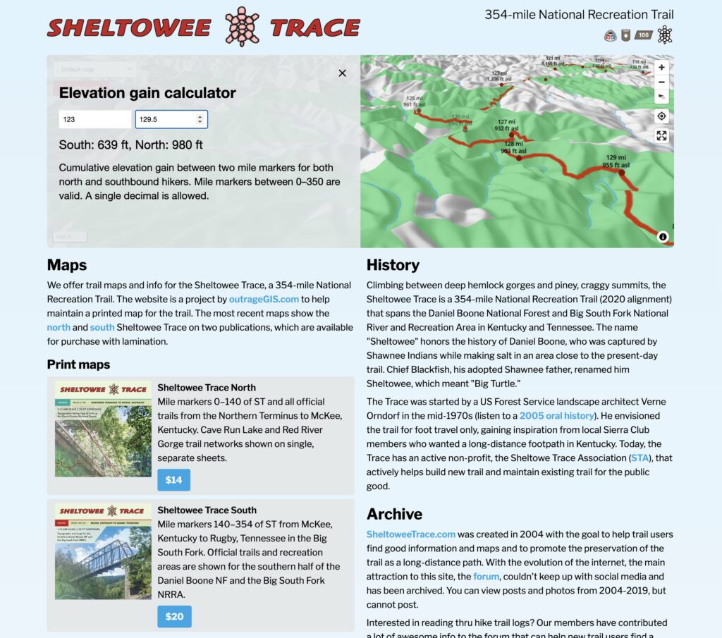
Furnace Arch, Sheltowee Trace

aalCave Run Lake Trail Guide
Distance: 6 Miles round-trip from trailhead
Difficulty: ++
Scenic Views: +++
Elevation Relief: 500ft ^
Ownership: Daniel Boone NF, USFS

Sheltowee Trace North Trail Map

Hiker Hiker Hiker

Imagine the scene around Clear Creek Iron Furnace in the 1830’s, the trailhead for this hike. Scores of men were clearing old growth trees by acres a week, cutting limestone from the creeks, and hauling iron ore rock from neighboring hillsides to fuel one of largest iron furnaces in Kentucky. Iron was produced roughly nine months out of the year. The process was a laborious affair, but the profit was great until much larger deposits of iron ore were found in the southern Appalachians and around the Great Lakes.

ST

The cut wood was slowly burned in dirt covered pit to make charcoal. The furnace was ‘charged’ from the top in layers of ore, charcoal, and limestone and when full, the furnace was stoked with forced air until the charcoal was white-hot and the whole furnace roared tremendously and blasted heated air, flames, and a shower of sparks from the top. That’s when the furnace was in blast and slowly molten iron would flow from furnace bottom and fill trenches of sand to make pig iron ingots. The iron ore found in rocks is basically rust and is rendered as elemental iron in series of chemical reactions in the furnace.

Today you can still see many aspects of the furnace operation. The hand-cut limestone furnace still stands. Glass and slag are found downstream. The fuel for charcoal of course grows around abundantly. The limestone outcrops as you ascend the trail south from furnace. The Sinks is a sinkhole in the limestone bedrock produced by the slow process of erosion. Atop the southern extent of this trail, you’ll find the same rugged sandstone the produces the great rockshelters in the Red River Gorge. In fact, if you continue hiking the Sheltowee Trace south, you’ll travel through the heart of the Gorge.

Furnace Arch is a low broad arch that resembles the iron furnace in shape. The sandstone outcrops in the area offer a few campsites, though no water along the ridge top. The scenic quality of this area, with blooming rhododendron against craggy boulders, is worth a day of exploration.

Sheltowee Trace & Bison Way Loop

Hiker Red River Gorge Backpacking Map
Distance: 5 Miles loop
Difficulty: ++
Scenic Views: +++
Elevation Relief: 300ft ^^
Ownership: Daniel Boone National Forest, USFS

Red River Gorge Backpacking Map: $14

Overlook in fall

The Sheltowee Trace spans the entire length of the Daniel Boone National Forest and a portion of the Big South Fork in Tennessee. The section through the Red River Gorge is one of the most spectacular, with this short segment visiting some of the most impressive overlooks and challenging side trails. Indian Staircase is an unofficial trail that climbs up a steep set of cliff ledges and can be found on the printed map. Although this loop uses part of a paved road, hikers have a chance for a short walk to the Red River suspension footbridge, the longest in the forest.

Suspension Bridge

Gladie Welcome Center
[Read more…]

0

Your Cart