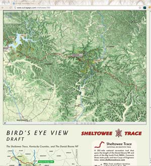
 Draft of the ST 3D
We have been working on our 3D map of the Sheltowee Trace. This Bird’s Eye View map shows the official forest service trails and recreation areas on a 3D map of the Pottsville Escarpment that separates the rugged Cumberland Plateau with the more rolling Bluegrass and Pennyrile regions.
We encourage you to explore this map give us any feedback. We will probably print portions of the map as insets in the Sheltowee Trace north map on which we are currently working.
Visit the map:
outrageGIS.com/sheltowee/3D


Thanks Scott. We have been pretty much tied up with other maps, but we’ll definitely keep folks updated when we get closer. Raymond and David, I understand it is a little confusing and normally we wouldn’t rotate our maps unless it was necessary for printing at a proper scale. For example, our Cumberland Gap map is rotated slightly because of the orientation of the mountain. For this map we felt like we could rotate 90 degrees since it is a Bird’s Eye View, which historically doesn’t follow the “north up” rule. They usually pick a view that looks the best.
Love your maps. Using your maps of the south portion of the Sheltowee now with the group from the Sheltowee Trace Org that is through hiking the trail. With those maps you have to continually orient them depending on the section you are using. I don’t really care where North is as long as it is marked…though normal convention would have it at the top. When hiking, one of the biggest things you are looking for are steep climbs or decents. It would be nice on the 3d, especially if used as inserts if you could mark vertical changes of more than 100′, or 2-3 elevation marks, maybe highlighed in orange or blue or something. When will the north map be available…the sooner the better. Thanks
You never put north to the side… EVER.
You’ve GOT to have north at the top, NOT to the side. YUCK!