Draft of interactive map, try it out.
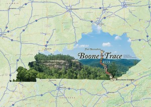
In 1775, Daniel Boone and his party blazed a route into Kentucky and created the pioneer settlement, Boonesborough. The Trace is often confused with the Wilderness Road, since they follow the same route through southern Kentucky, but the Trace predates the Wilderness Road. Boone established the main road through the Kentucky mountains and into the outer Bluegrass. That road would later be known as the Wilderness Road. Boone Trace leaves the Wilderness Road south of Richmond, Kentucky and travels north to Fort Boonesboro.
Today, plenty of historical monuments exists along drivable portions of the Trace. BooneTrace1775.org describes, “There is a monument at the Daniel Boone Park in Flat Lick, Ky. Emblazoned on it are these words which pretty much say it all–  ‘No other trail is of greater historical significant to the founding of Kentucky and opening of the west (than Boone Trace).'”
This map attempts to show a driving tour of the Trace and aggregates many of the cultural and historical destinations once could visit today. It was designed for mobile web browsers and uses Leaflet to power the interactivity.

Flash-type interactive map, 2004
It’s pretty amazing to see how much dynamic web mapping has changed over the past decade. Before, we had Flash content and static layouts, as illustrated by the Elkhorn City Living Cemetery project. Today, we have data-rich maps that take a fraction of the time to create.


Speak Your Mind
You must be logged in to post a comment.