
Arboretum Woods Poster
What can students do with a smartphone, ArcMap, and a linux server? More than just have fun outside!
15 student teams from two GIS courses at the University of Kentucky mapped, measured, and photographed 603 trees in the Arboretum Woods. Each team (which adopted colorful team names) was given (approximately) an acre zone. They used common mobile devices and low-cost apps to GPS and photograph the most significant trees.Â
Each team made a poster and presented them during a 2014 International GIS Day event in the Thomas Poe Cooper building on UK’s campus. It was widely attended and praised for the strength of student teams’ achievement.Â
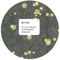 Since students photographed each tree, we made an interactive map that shows these photos and can be used for geolocation while in the woods. Using Leaflet, GeoJSON, and a Linux server, student SWEB accounts host data that feeds this interactive map:Â Look at trees now!


Speak Your Mind
You must be logged in to post a comment.