Canopy zipline tour mapping assignment
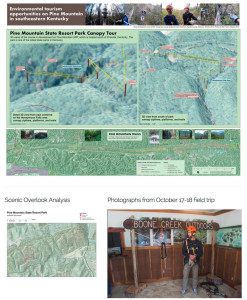
What wild weekend and mapping task! Boyd led an undergraduate GIS class at the University of Kentucky and endeavored to map and analyze environmental tourism assets on Pine Mountain. During discussions with Pine Mountain State Resort Park, we discovered a canopy zipline tour, one of the first in the state, was being installed in the park.
We contacted the developer, Burgess Carey, and asked if we could map the canopy zipline course. We participated in a canopy tour at Boone Creek Outdoors to better understand this unique mapping challenge. We subsequently went to Pine Mountain and GPS located the canopy platforms and measured their heights. In the lab we made 3D views with ESRI’s ArcScene and mapped nearby recreational assets using ArcMap.
Explore student maps, GoPro video, and photographs of Pine Mountain and Boone Creek Outdoors on this website.


Speak Your Mind
You must be logged in to post a comment.