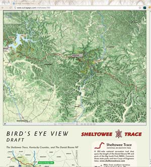
 Draft of the ST 3D
We have been working on our 3D map of the Sheltowee Trace. This Bird’s Eye View map shows the official forest service trails and recreation areas on a 3D map of the Pottsville Escarpment that separates the rugged Cumberland Plateau with the more rolling Bluegrass and Pennyrile regions.
We encourage you to explore this map give us any feedback. We will probably print portions of the map as insets in the Sheltowee Trace north map on which we are currently working.
Visit the map:
outrageGIS.com/sheltowee/3D

 We are introducing our new map and GPS datapack series for the Great Smoky Mountains. We’ve created an easily printable map for every trail listed in the Great Smoky Mountains Association’s Hiking Trails of the Smokies, the brown book, also known as the “Hikers’ Brown Bible.”


