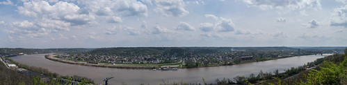
Robinson Forest Camp Trail Map Exercise

Robinson Forest Camp trail map

Robinson Forest Camp trail map

As part of UK Natural Resources and Environmental Sciences 2015 Summer Camp, I taught a one-day GPS and GIS exercise to map the interpretive trails around base camp. With seven undergraduates and their mobile devices and one Trimble ProXRS, we split into three teams. One team focused on the trail network and GPS mapped trail alignment and intersections. A second team mapped interpretive sites on the left-side of trials, while a third-team mapped right-side features.

In the second-half of the day, we worked in the classroom and on laptops to make a map in ArcGIS. Some students had GIS software experience and helped their fellow classmates to make a map as a geospatial PDF and use on their mobile devices. A GeoPDF is a mobile map that doesn’t require a cellular data connection to function.

Student Observations and Analysis of UK Campus Celebrations

Basketball Celebrations

Map of basketball celebrations

During two weekends this spring, students in UK GEO 309 (Introduction to GIS) were asked to log celebrations associated with UK men’s basketball NCAA tournament around campus in selected zones. Student teams were then tasked to map and analyze these patterns of celebrations during the last week of class. Their maps and photographs are shown here.

Their topics include: locations of campus rental properties, noise pollution from major party locations, population density, and changes in social media engagement during and after games. 

Distress In Kentucky

Distress In Kentucky: Link to image

Link to image

Severe socioeconomic distress exists in both urban and rural block groups. Of the 311,000 people in severely distressed block groups, 60% are urban. In rural block groups, as socioeconomic distress increases, so do indicators of environmental distress. Rates of wildfire and surface coal mining nearly double between distressed and severely distressed rural block groups (chart 1).

DistressInKentucky_byBlockGroup_2015_ChartOne

A broader point can be made with this analysis. Adventure tourism is a growing business nationally and a determined focus of economic development in Kentucky. Many of these types tourists seek a large network of land and water trails, especially in pristine areas. Much of eastern Kentucky had this potential, except for the cycle of unsustainable surface mining and the attending boom-bust economy that left derelict landscapes. Poor areas with scarred lands face a much harder path attaining success in this new tourism. But there is always hope. Perhaps the type of adventures grow (e.g., ATV and bridal parks on large reclaimed strip mines) or maybe regional coalitions stitch together corridors of unaltered land. The benefits are not just in tourism dollars, but also in the activity of recreation. Imagine a distress index map that also included bad health indicators.

Map was created by Boyd Shearer for GEO 309, Introduction to GIS in the Department of Geography, University of Kentucky during the Spring Semester, 2015.

Sources of data:
Kentucky Department for Natural Resources, Division of Forestry. January, 2015.
Kentucky Department for Natural Resources, Surface Mining Information System (SMIS) database, accessed March 15, 2015: http://minepermits.ky.gov/Pages/SpatialData.aspx
Short, Karen C. 2014. Spatial wildfire occurrence data for the United States, 1992-2012 [FPA_FOD_20140428]. 2nd Edition. Fort Collins, CO: Forest Service Research Data Archive. http://dx.doi.org/10.2737/RDS-2013-0009.2
US Census Bureau. 2015. 2009-2013 American Community Survey (ACS) 5-year Estimates.

2009 Sheltowee Trace South now available

Laminated ST South map

Laminated ST South map

After many requests from hikers and map enthusiasts, our map that shows the ST 2009 southern alignment (Pickett State Park as southern terminus) is back in a limited edition print run. Folks called nearly everyday asking for this map. We answered with a custom map edition.

While the southern terminus is now at Burnt Mill Bridge in the Big South Fork, this is the only map that shows the Sheltowee Trace between the Big South Fork and Turkey Foot. This map also shows the Kentucky Trail and long portions of the John Muir Trail, which the ST also uses.

This laminated map is now for sale at $24.

Topography and Hemlock Habitat

Elevation range in feet within an area 164-foot square

Elevation range in feet within an area 164-foot square

Sheltered coves and north-facing cliffs are hemlock habitats in Eastern Kentucky. This map shows range of elevation change within a 164-foot square area. Red areas indicate the highest relief, which are mountain slopes in the coal fields, and cliffs along the Pottsville Escarpment and Pine and Cumberland Mountains fault. Since most cliff is sandstone, areas indicated as cliffs would presumably have sandy soils, which is a condition for other evergreen species habitats, e.g., mountain laurel and rhododendron.

This is first-run test. Further analysis would include adding aspect, evergreen canopy cover, and soils to better refine predicting hemlock habitat.

Student final projects, Fall 2014

A selected gallery of student final posters from GIS courses at the University of Kentucky. Classes include, FOR 330, NRE 355, and LA 355.

Mammoth Cave NP Acoustic Bat Survey, by Shelby Fulton

Mammoth Cave NP Acoustic Bat Survey, by Shelby Fulton

Kentucky's Best Public Land Waterfowl Hunting Areas, by Zack Hackworth

Kentucky’s Best Public Land Waterfowl Hunting Areas, by Zack Hackworth

Kentucky's Oil Production in the Illinois Basin, by Clark Higgins

Kentucky’s Oil Production in the Illinois Basin, by Clark Higgins

April, 2014 Kingdom Come State Park Wildfire Analysis, by Kyle Howard

April, 2014 Kingdom Come State Park Wildfire Analysis, by Kyle Howard

University of Kentucky Car Collision before and during Campus Contruction, bt Erin Klamic

University of Kentucky Car Collision before and during Campus Contruction, by Erin Klamic

Kentucky's Deer v. Car Collisions 2011-2013, by Jesse Hunter

An Analysis of Kentucky’s Deer v. Car Collisions between 2011-2013, by Jesse Hunter

Analysis of Car Crashes in Bullitt County, by Austin Sauer

Analysis of Car Crashes in Bullitt County, by Austin Sauer

Potential Effects of the Emerald Ash Borer on Stand Density, by Andrew Emery

Potential Effects of the Emerald Ash Borer on Stand Density, by Andrew Emery

A Neighborhood’s ‘Green’ Index

NeighborhoodGreenIndex_MLKNAA map showing ratio of property parcels covered in healthy canopy in the Martin Luther King Neighborhood Association in Lexington, Kentucky.

Using National Agriculture Imagery Program (NAIP) 2012 aerial imagery, a Normalized Difference Vegetation Index (NDVI) was created. Values greater or equal to 0.3 were assumed healthy canopy and (mostly) verified by visual inspection from imagery and summer field observations.

319 Photos

We’re gearing up with a new online #SheltoweeMap with a participatory aspect. Keep tuned and get a map for exploring.

In the meantime, check out some photographs from the Sheltowee Trace from our archive: http://pixel.outragegis.com/main.php?g2_view=keyalbum.KeywordAlbum&g2_keyword=Sheltowee+Trace

and current photos: https://www.flickr.com/photos/28640579@N02/

Woodland Art Fair time, 2014!

Come down to the Woodland Art Fair this Saturday and Sunday, August 16 and 17,and check out our new Sheltowee Trace North map. We have a couple neat projects in the works and would like to hear your trail adventure stories.

Cover wrap of our new Sheltowee Trace Map

Cover wrap of our new Sheltowee Trace Map. Click to enlarge.

[Read more…]

Sheltowee Trace North map

Trails in the northern half of the Daniel Boone

Trails in the northern half of the Daniel Boone

We are now printing the Sheltowee Trace North map, which covers the ST and official trails between the Northern Terminus and Mckee in Jackson County, Kentucky. That’s 138 miles of ST and  130 miles of official trail. The map is same scale as our previous ST south maps, but the sheet size has been enlarged to 19″ x 27″ and packs down to 4.5″ x 6.5″. We will also offer a lamination and heat press service to make these maps bomber in the field.

Cover wrap of our new Sheltowee Trace Map

Cover wrap of our new Sheltowee Trace Map. Click to enlarge.

A couple unique additions to this title might be useful for the serious trail enthusiast. The map is formatted to show the trail network of Cave Run Lake and Red River Gorge on single, separate sheets. The new ST reroute around Morehead and new trails in Cave Run are located. Groceries, public libraries, power lines, and pipelines are located. We’ve added 1,000 m UTM grid. What else? Lots of love and devotion for the trails of the Daniel Boone.

Overview

Low resolutions drafts of the press sheets (note these previews require Flash). These have been altered in final version. The only way to see the finished map is to hold it in your hand!

Northern Terminus
Cave Run Lake
Red River Gorge
Southern Gorge, Turkey Foot, and McKee

Just like the South ST map, when the ST leaves a sheet it has a letter in a red box as label to match the trail on the next sheet. Just follow A…B…C… for 138 miles.

Thanks for the input in correcting thre above drafts!

A Postcard from Puerto Rico

Photos and a block diagram of NE Puerto Rico

We recently visited Puerto Rico and explored the island’s public parks and forests. Spanish forts in San Juan are wonderfully preserved by the National Park Service and the El Yunque cloud forest is the only tropical rain forest maintained by the National Forest Service. These ares are public treasures and hard to capture by photography alone. You might have seen postcards with extruded maps of mountainous areas and tourist destinations. That’s the quick experiment here, but done just two-dimensionally.

Some downtown Lexington destinations

Sample of custom guide for Lexington destinations

Sample of custom guide for Lexington destinations

Imagine a lot of new people arriving to a downtown hotel and you need to recommend unique destinations for dining. I guess you could give a list that they could yelp, but wouldn’t a paper map add a nice, personal touch?

A small map of interesting places to eat and play

A small map of interesting places to eat and play

We have marveled at the growth of mobile maps that tap in largest collective database ever generated and, unfortunately, the subsequent loss of interest in paper maps. While mobile can help locate you in an unfamiliar city with GPS, the map data can be uninspiring and wildly inaccurate. The problem I suggest is the zoom, since we expect ever complex revelations with increasing zoom levels. We all know it’s a big bummer when you zoom into a blank screen, right? We think a static maps can better stimulate imagination and invite navigation into unfamiliar areas.

This is a small experiment integrating 3D maps, photography, and a few SketchUp models to give a quick sense of place and provide a simple navigation tool to explore the city.

McConnell Springs Trails

3D map

3D map

A perspective view of trails and destinations in Lexington’s McConnell Springs park. This historic location host notable destinations such as the Blue Hole, The Boils, the Old Bur Oak, and the Final Sink. This map will be offered to park after some additions and modification, perhaps adding a more realistic model of the Science Center.

Modeling University of Kentucky’s Campus

Campus pedestrian network

Campus pedestrian network

We’ve been visualizing campus paths with new GIS data provided by UK’s Facilities Information Services. Students have GPS mapped cut-through paths (they lovingly call cow paths) and other students have placed SketchUp models for campus town buildings. This is a preview of some of the data, so stay tuned for a featured analysis.

Outstanding Geography Teacher Award

Outstanding Geography Teacher Award, 2014

Outstanding Geography Teacher Award, 2014

Boyd Shearer was awarded the Outstanding Geography Teacher Award for his GIS courses at the University of Kentucky Department of Geography. The award was presented by the Geography Majors during the department’s annual Semple Day awards presentation on April 25, 2014. He’d just like to say, awesome! and he’ll keep trying his best to make mappers.

0

Your Cart