Sunset and moonrise
Bike Lex Map in draft
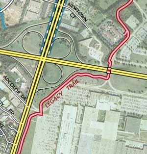 After a few grueling weeks of cartography, we have posted a draft of the new Bike Lex Map. The goal of this map is to help pedestrians and bikers enjoy the public spaces of central Lexington, Kentucky. The map should also help veteran bikers find new biking routes through the city and direct newbie bikers to good resources about biking in the city. Parents will also find the map helpful, because we have mapped many of the public parks and their paved paths. They can discover a new park to take their child’s first bike!
Proposed format: 26″ x 40″ printed map and companion website. Samples can be found here: http://www.bikelex.com
What does this map offer?
- Alignments for the Legacy Trail, Town Branch Trail, and other shared-use trails.
- Mountain biking trails in Veterans Park.
- Bike lanes & shoulders, walking paths, unpaved foot & bike trails, and other paths & spaces pedestrians might enjoy.
- Best routes for biking on Lexington streets.
- University of Kentucky bike routes.
This guide is in the early stages of development. If you would like to contribute, please contact us with your opinions, suggestions, or requests.
Thanks and happy trails!
Archive of Webcam Animations
In the spring of 2009, I wrote a couple scripts to automate collecting webcam and visual satellite images of the Great Smoky Mountains National Park and creating animations from them. Recently I put the archive of those animations online after a few requests. The archive also records the past 24-hour temperatures, precipitation, and snow depth for the day selected.
Questions like, when’s a good time to see fall colors, can be now be answered with a visual assessment from last year’s observations. Combare the days between October 10 and October 22, 2009, for a good answer. Between those days, the smokies received its first snowfall.
The archive can be found here: http://www.outragegis.com/weather/img/animation
Woodland Art Fair this weekend!
Come down to the Woodland Art Fair the is Saturday and Sunday and check out our new Great Smoky Mountains National Park map. Mention that you read this post on our News section and get $2 off any map purchase and a special gift. [Read more…]
Webcams for Great Smoky Mountains
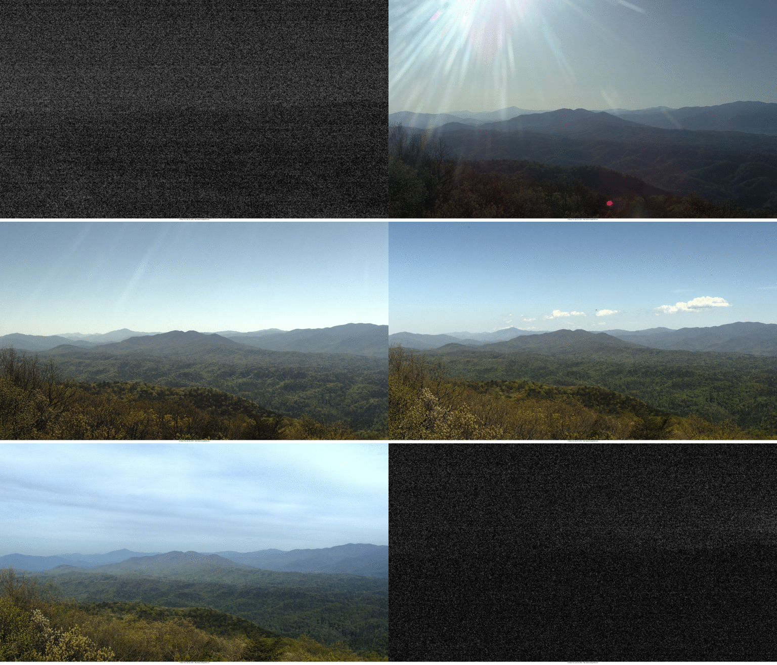 After a few months of intermittent outage, the four webcams that cover the Great Smokies are all working. Now we can compare sky conditions on both sides of the mountain and also observe sunrise and sunset. The webcam animations also work, too!
You can view these webcams on our weather page: outrageGIS.com/weather/grsm
2010 Draft of New Great Smoky Mountains Trail Map
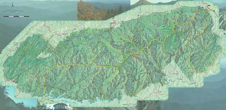
Welcome to our new topographic map of the Great Smoky Mountains National Park. At 1:50,000 scale, this will be the most detailed map published of the park. We’ve added a couple new features to help better navigate in this wonderful national park, such as the new official trail system and elevation contours. We’re almost done!
You can check out a public draft here: http://www.outrageGIS.com/grsm/draft and please tell us what you think in the below comments section.
New Features:
- 1:50,000 scale, which is 140% enlargement of the Trails Illustrated map
- 100-foot contour interval with 500-foot index contours
- Canopy cover type indicating deciduous, evergreen, shrub, grass, and open areas
- 1-minute Geographic coordinate grid for GPS
- Elevations for trail intersections and other points of interest
- Mileage shown between trail intersections and campsites
- Updated official trails and campsites
- Unique hillshading shows topography clearly
El Niño to make the mountains colder and drier this winter
Predicting climate in the old days relied upon observing cues in nature. The Farmers’ Almanac finds that people looked at woolly worms in late summer in get a sense of winter. The more black hairs on the worm, the colder and wetter the winter. Of course woolly worms come in all configurations of black and orange colorings so how could a worm’s coat predict winter? It can as an analogy; you look at the forecast to decide which coat you’re going to wear before leaving home. I think you would want to wear a black coat as opposed to a white coat on a very cold and sunny day to maximize the amount of solar energy you could absorb. Woolly worms just plan far ahead.
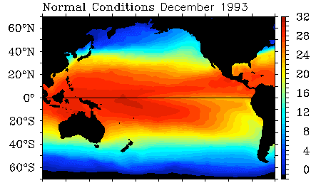
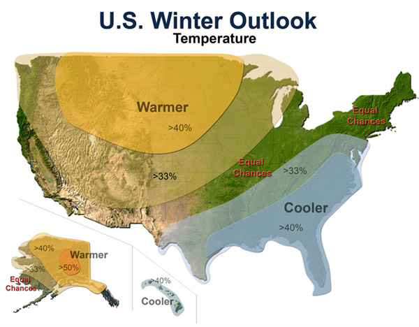
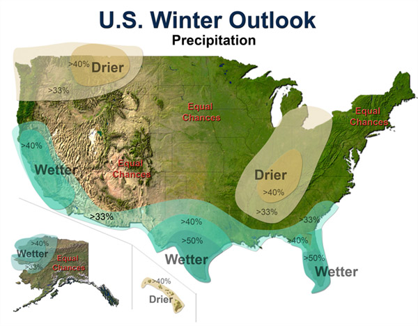
Today we track global changes in wind patterns and sea surface temperatures to predict weather conditions. NOAA’s Climate Prediction Center has issued a climate forecast for this winter based on the El Niño pattern emerging in the Pacific Ocean.
Below are winter predictions for the U.S. indicating greater or lesser chances for departures in average winter temperatures and precipitation.
El Niño is a departure from average sea surface temperatures created by a change in the intensity and direction of equatorial winds. In a normal period, strong easterly trade winds blow across the Pacific and upwell cold, nutrient rich waters on the west coast of South America. These same winds also pile up water in the western Pacific so that the sea surface is about 2 feet higher at Indonesia than at Ecuador.
In an El Niño cycle, the winds are not as intense and warmer sea surface temperatures extend further to east. This change has a global impact on weather with increased precipitation on the west coast of South America and the south & east coasts of North America. Warmer than normal conditions also occur at higher latitudes in North America and over the Pacific ocean.
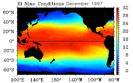
El Niño Sea Surface Temperatures in °C
First freezing night in the Great Smokies
![]() Overnight the temperature dropped to 25° F at the Newfound Gap weather station, elevation 5,000 ft. Mt LeConte at 6400 ft above sea level recorded a low temperature of 31° F. The slight warming at 1,400 ft higher in elevation is caused by a temperature inversion that most frequently happens in autumn mornings.
Overnight the temperature dropped to 25° F at the Newfound Gap weather station, elevation 5,000 ft. Mt LeConte at 6400 ft above sea level recorded a low temperature of 31° F. The slight warming at 1,400 ft higher in elevation is caused by a temperature inversion that most frequently happens in autumn mornings.
The lowest temperature recored at Mt. LeConte for September 29 was 24° F and that happened in 2003. The coldest night ever recorded since 1988 was -22° F, which occurred last February 4.
Station reports for 7:30 am, September 28 – 7:30 am, September 29:
STATION             ELEV    HIGH    LOW     PCPN    SNOW DEPTH
SUGARLAND CENTER    1600     75      45     0.00
NEWFOUND GAP        5000     62      25     0.00
CADES COVE          1900     73      44     0.00
OCONALUFTEE         2040     79      42     0.00
MOUNT LECONTE       6400     57      31     0.01

http://www.outrageGIS.com/weather/grsm
All weather cams are up
After a few months of intermittent outage, all four weather observation cameras for the Great Smoky Mountains National Park are now operational. We archive full-day animations for 3 webcams and the visible satellite view of the park every day at:
http://www.outragegis.com/weather/img/animation/yesterday.
For previous days, you can access other days by replacing “yesterday” with the 6-digit year month day combination. For example, for September 24, 2009 replace “yesterday” with “090924”and create this link:
http://www.outragegis.com/weather/img/animation/090924.
For highest resolution images, just click on the preview images.
The two National Park cameras are located on Look Rock and Purchase Knob. Look Rock camera overlooks most of the park. The two National Forest cameras, Cold Mountain and Joyce Kilmer Wilderness, overlook small portions of the park.
Now let’s watch fall pass in the mountains!
Sept 12: Sheltowee Trace Meeting in Winchester
The Future of the Trace: Sept 12, 2009
Join a group of trail enthusiasts and forest & park officials at the Daniel Boone NFS headquarters in Winchester to discuss the future of the Sheltowee Trace. We need as many committed folks as possible to attend. Voice your support for the Sheltowee Trace.
If you would like to attend, you can RSVP here with a comment so we can plan for breakfast and lunch!
Time: 9:30am
Where: Clark County Extension Office (map below)
1400 Fortune Dr
Winchester, KY 40391-8292
(859) 744-4682
Preliminary Agenda
9:30 to 10:00 – Meet and Greet – Coffee, Juice and Bagels, Donuts provided.
10:00 Opening Comments
- Frank Beum, Forest Supervisor, Daniel Boone National Forest
- Steve Handley, Big South Fork National Recreational Area, National Park Service
- Carey Tichenor, Ky State Parks and Recreation
- Steve Barbour, Interim Executive Director, The Sheltowee Trace Association
10:30 – Updates on the Current Condition of The Trace in each Ranger District and Plans for the next 12 to 24 months
10:45 – Current Management Plan Development
- Federal and State Funding Levels
- Challenges of a Muti-use Trail
- Current on-going volunteer programs
- Short Term and Long Term Maintenance Issues
- Trace Blazing – Signage
- Land Acquisition
- Trace Relocation
- Maintaining Easements
- Development of the Volunteer Base
- Promoting The Trace across the state
Following these discussion will be a session on forming the Sheltowee Trace Association, a non-profit dedicated to promoting and protecting this National Recreation Trail.
Map:Here
Woodland Art Fair, Aug 15-16
Come down to the Woodland Art Fair the is Saturday and Sunday and check out our new maps. We will have the spring release of the Red River Gorge and the Sheltowee Trace South, both of which were designed and printed in the past 6 months. The map to out booth is provided below: [Read more…]
Sheltowee Trace Suspension Bridge Quiz
How many scenic suspension bridges exist on the Sheltowee Trace and where are they? If you think you know the answer, then please take our quiz and you might win some free maps.
Directions: If you can name or locate all of the suspension bridges on the Sheltowee Trace, then you can receive our new Sheltowee Trace map for free. Name all of the them and tell us which is the largest and which is the smallest, then you’ll get three free maps of your choice.
How to submit you answer: Email your answer to contest@outrageGIS.com beginning Friday, August 21, 2:00pm EST. You must be the seventh correct email to win. You only get one try and we’ll take your first answer.
If you’re not the 7th person to answer either question correctly, then you will still receive a bonus coupon to use at our online store. Just give it a try!
![]()
Ok….which bridge is this? If you need a little help, visit http://www.sheltoweetrace.com
Lexington Community Gardens
![]()
London Ferrell Community Garden
Locations of Lexington’s community gardens. Gardens maintained by Seedleaf: Nourishing communities by growing, cooking, sharing, and recycling food.
Animations of the Atmosphere
As a lover of the atmosphere and sun, I want to see how light and sky change over the course of the day. I also want to see how large-area weather events, such as the passage of a front, impact different places in the Great Smoky mountains. The inspiration behind this page was a desire to record weather changes at different elevations on a mountain and to help the photographer in me better understand a secretive and dynamic landscape.
Enter Yesterday: a site of prior-day animations of federal web cams and satellite imagery located here at http://www.outragegis.com/weather/img/animation/yesterday. Note this page always shows conditions for the prior day since they are full-day timelines.
The Great Smokies have about one mile of vertical relief and weather conditions can be dramatically different depending on your elevation. Whatever it’s a line of thunderstorms or fog in the valleys on a calm morning, this is a visual record of evolving conditions…only of course it happens during daylight. For the weather nut who likes to take it a step further, the page gives data from park’s 5 weather stations for the same day….and it’s all archived.
How was it done? After tinkering with ImageMagick and FFmpeg, I made a script that creates full-day animations of the webcams in the Great Smokies and visible satellite images from NOAA. What will it become? Consider it a visual archive of the atmosphere and movements of the Sun in the Great Smokies. Any suggestions are welcome.
Some notes for updates: I haven’t fully utilized the flash embedded video (see the two samples below, top is animated gif and below is embedded flash video). The problem is setting animations in sync together, e.g., sun rises at the same time in all movies. With an animated .gif, I think you simply need to refresh your browser after all of the images are loaded to get a partial sync. A better solution is out there. I can also increase the sampling rate for smoother play; now it’s two samples an hour.
[flv:http://www.outragegis.com/weather/img/animation/090603/PurchaseKnob.flv 400 290]
These are also archived, so if you go to the smokies for a backcountry trip, you’ll be able to find your days here.


