Weather in the Smokies this spring has been very active. Just last week, Mt. LeConte had 14 inches of snow. This morning the sun rose as a golden fireball that lit the mountain ridges in clear relief. Mt LeConte is the peak at the sun’s 4 o’clock position. Over six inches of snow lingered at the highest elevations for a few days. May has given measurable snowfall.

View from Look Rock
Easter Morning Sunrise
April 12, 2009 by
Fire in Cades Cove
March 30, 2009 by
Controlled burning will impact Cades Cove through April. From the park’s website: “Fire managers at Great Smoky Mountains National Park plan to begin conducting a series of controlled burns of fields in the interior of Cades Cove on Tuesday March 24, 2009, if weather conditions permit. Park managers plan to burn three to seven different parcels totaling up to 300 acres from now until May 1.”

View from Look Rock
March Moon Rise
March 10, 2009 by
Tonight at 10:28 P.M. we will have our March full moon, the last full moon of winter. Full moons throughout the year have names given by early settlers and Native Americans to indicate important seasonal activities…such as a Harvest Moon and Hunter’s Moon.
The March full moon is know as a Worm Moon in the Farmer’s Almanac, for the warming of the soil and emergence of earthworms that herald the return of robins and spring. Also known as a Sap Moon for rising maple tree sap, a Lenten Moon for catholic settlers, and a Crow Moon for the cawing of crows that indicate the end of winter.
Below are photos of the moonrise above the Great Smoky Mountains. The far mountain peak the moon rises over is Mt. Le Conte.

Trail Conditions after the Ice Storm
February 24, 2009 by
The Red River Gorge was impacted by the January ice storm. The gravel FS roads were closed for about a week, but they are now open. All of the trails in the Red River Gorge proper have been cleared of debris, except Courthouse Rock Trail, Rough Trail over Parched Corn Creek, and the Sheltowee Trace north of Bison Way. Trails in the Clifty Wilderness has not been cleared, and since no chainsaws are allowed there, it might take time to clear.
The debris is problematic, but not a deal breaker in my opinion. Though if you are backpacking and/or have leashed dogs, a down tree on the trail is problem. I went out Swift Camp Creek east of 715 for about a mile and the trail was not that bad. As with any backcountry adventure, you’ll expect an element of danger so please use an extra measure of caution on trails in the Clifty Wilderness…and tell us how they are!
Boyd
Winter Storm in the Bluegrass
December 16, 2008 by
 Winter storm warning, Dec 15-16, 2008.
“The National Weather Service will issue a winter storm warning when a dangerous combination of heavy snow, with sleet and/or freezing rain, will occur or has a high probability of occurring within the next 12 hours.”
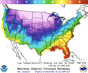
Severe winter weather events are notorious to forecast. Our TV weathercasters had a range of predictions from a half-inch of ice accumulation to 5 inches of snow. The National Weather Service (NWS) had a similar forecast. After the event, we had a lot of variability across the region, so in part, all of the predictions were somewhere correct. I think the NWS made a good prediction on where the bad weather would happen, but the severity was hard to calculate.
The above map (shown in greater detail below) shows low temperatures across the U.S. and highlights the problem with forecasting such a large storm. The huge temperature change from -20° F in the northern states to 60° F in the southeast indicates two vastly different air masses in close proximity. The greater the difference, the more difficult the predictions. When the air masses begin to interact and do their dance, that’s the problem.
It’s easy to forecast calm conditions, but when the weather becomes bad, the severity is determined by how different the air masses are and how much they interact. Two similar air masses doing a “big dance” will have little impact. Two vastly dissimilar air masses just interacting slightly will produce enormous weather. Though we can measure the characteristics of air masses, the problem is that we can’t predict how they’ll interact.
The basic setup we had here was that cold polar plunged southward, and displaced the warmer, more moist tropical air. As the warmer, less dense air rode over the advancing colder, denser air, precipitation fell as rain. As it traveled through the colder, ground layer of air, it froze on surface contact. That’s freezing rain. However when upper layer of air approaches the freezing point, precipitation could fall as snow or sleet. As this boundary zone between air masses changes, the vertical temperature profile changes and so does the type precipitation that hits the ground.
Can you feel it for the weathercaster trying to predict this stuff?
Watches and Warnings Map, Dec 16
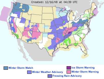
Above map is the Watches and Warnings for the U.S., December 16, 2008. Compare this map to the below map, which forecasts low temperatures for this morning. Note the axis of warnings from Texas to Pennsylvania which overlays a sharp temperature contrast between the polar air to the northwest and tropical air to the southeast. This steep temperature gradient is almost 90° F and is zone of interaction.
Low Temperature Map, Dec 16
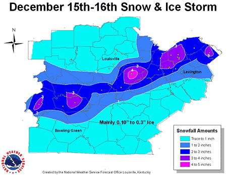
The below map shows snow and ice totals for the Bluegrass region.
Weather influenced by the Great Lakes
December 7, 2008 by
We had a widespread snowfall this weekend in the Bluegrass. While we only had an 1″ or less over the central and northern Daniel Boone country, all we need to do is put a chain of great lakes to our immediate northwest if we wanted some truly deep snow.
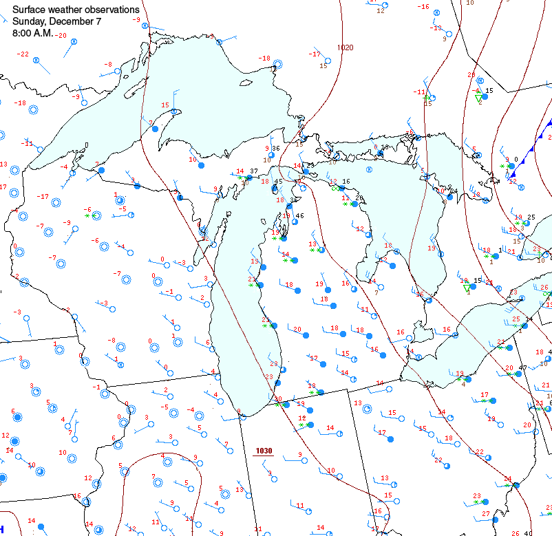
Enlarge this map and look at dramatically different weather around the Great Lakes today.
One of the most obvious and striking winter weather conditions is the atmospheric influence of the Great Lakes. When high pressure builds to the west of the Great Lakes and there’s a prominent northwest-to-southeast surface wind flow, weather is significantly different downwind of the lake compared to upwind. This often produces lake effect snow that can truly bury southeastern shore cities. However, the same influence can reach far south into Kentucky and the Appalachians.
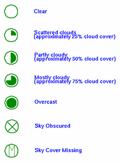
The difference in weather can be outstanding, as people who live near the lakes know very well. Observe weather on both sides of Lake Michigan. The red number indicates the temperature in °F and the circle indicates cloud cover. A solid circle is completely cloudy, and an empty circle represents clear skies. The barb indicates wind speed and direction (see below for legend).
Compare Lake Michigan’s west shore with its east shore. The west shore of Lake Michigan is cold, below zero, and cloudless. Weather on the east shore of Lake Michigan is 20°F warmer, it is cloudier, and snow is falling, as represented by the green asterisks.
The cause of these conditions is simply the great reservoir of heat that the lakes contain and transfer to the atmosphere through evaporation. Though the lakes are slowly cooling through winter, they are significantly above freezing across a large area. When a colder, dry air mass blows over the lakes, evaporation will transfer heat and moisture into the air mass. As the rising, warmer air cools, if often condenses resulting in cloudiness and heavy snow; the lake effect snow machine. Also note the how far south the warmer air has penetrated compared to other locations at the same latitude.
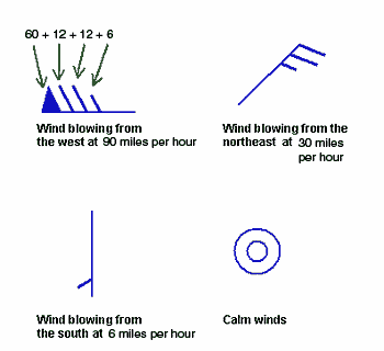
For example this station here:  is reporting that the current temperature is 55 degrees F, the sky is clear, and the winds are blowing from the north at 18 miles per hour.
And this station  is reporting completely overcast conditons, winds from the north at 24 miles per hour and the temperature is 58 degrees F.
Sundog over Lexington
October 11, 2008 by
A sundog is a bright spot to the left or right of the sun (usually occurs in pairs) that typically happens around sunset or sunrise in high cirrus clouds.
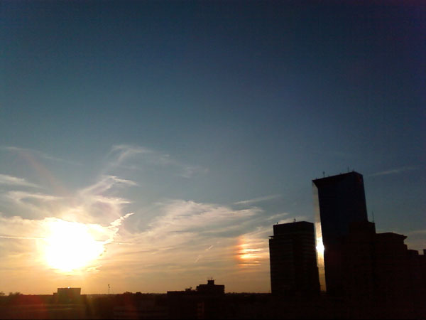
This sundog occurred Friday night over Lexington and there is a companion sundog to the left, but it is out of the frame. The bright spot to the far right is a reflection off our “Big Blue” building.
Sundogs form when a couple unique conditions are present. Cirrus clouds are the atmosphere’s highest clouds and are composed of small ice crystals. These ice crystals are were the sun creates the show.
When the sun is close to the horizon and there’s a significant layer of cirrus clouds, which should be noted are curving towards the horizon, sunlight will do 3 things: 1) be reflected at a predictable location causing the bright spot, 2) refracted at the same spot causing a rainbow, and 3) scattered throughout giving the sundog a general reddish cast.
While not rare, sundogs are uncommon and have been heralded as both good and bad omens by ancient peoples.
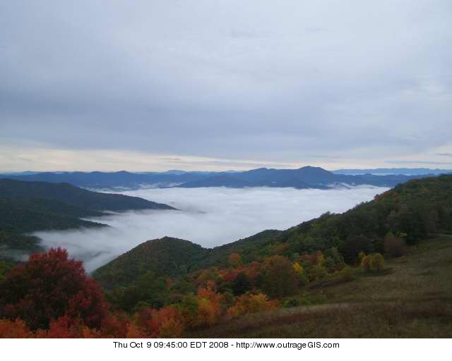
Morning in the Great Smokies
October 9, 2008 by
Fog below Purchase Knob on the morning of October 9, 2008
Drought Conditions in the Daniel Boone
September 20, 2008 by
 Precipitation, or lack thereof.
The Daniel Boone National Forest averages between 43 inches a year in the northeastern section to 53 inches in the southwestern section around the Big South Fork. Currently, the forest is in a precipitation deficit of around 4-8 inches. With the approaching fall and the driest period of the year, the forecast is for a seriously dry time in the woods. This is especially true to south and east, but the high ridges are dust dry now.
The most problematic aspect of a drought this time of year is forest fire hazards. After trees drop their leaves under cloudless skies, the forest floor experiences direct sunlight and high evaporation rates. This produces abundant fuel for forest fires.
So if you’re planning a trip this autumn, be careful with camp fires and consider using stoves for cooking and battery candles for illumination. The following discussion looks at national maps of drought severity and outlook.
Hurricane Ike
September 11, 2008 by

Postscript
Ike’s precipitation never made it to the Daniel Boone. The winds did however. Hurricane force winds were recorded in Louisville, Kentucky and a strong wind advisory was posted for Lexington and the Daniel Boone. We’ll have to wait and hope for another storm to bring much needed rain to the state, though we wish for no dangerous hurricane.
Current Track for September 11
It was 47 years ago today that Hurricane Carla made landfall and battered the central Texas coast with wind gusts to 175 mph, and up to 16 inches of rain. Carla also spawned a tornado which swept across Galveston Island killing eight people. The Category 4 hurricane claimed 45 lives and caused $2.22 billion dollars in damage.
Forecasters haven’t directly compared Ike to Carla yet, but this hurricane will most likely impact Kentucky. After making landfall Friday, Ike should swing northest north and aim for Kentucky and the Daniel Boone National Forest. The final track however has yet to play out, but if the bluegrass gets under this tropical depression, the state undoubtedly will do some catching up on the meager precipitation it has received this summer.
On average, the central part of the state receives about 11 inches of rain in the summer, however only 8 inches has fallen from June-August and none so far in September. In September, one of the bluegrass’s driest months, rainfall totals average about 3 inches. Last September, less than one inch of rain fell that month. Bone dry.
 Enter Ike
A storm of this magnitude could definitely bring 3 inches of rain to the bluegrass. It could bring 6 inches. If it strengthens to a category 4 storm above the warmest section of the Gulf of Mexico as predicted, it will contain an enormous amount of energy and water vapor. Hurricanes this strong produce more energy in a day than the U.S. produces at all power plants in a year. That’s a lot of juice and Ike has to go somewhere.
Hurricanes need over 80-degree F surface water temperatures to exist. Every degree above that is like adding gasoline to a fire.
Below is a map of current surface water temperatures
![]()


