Ridge Trail at Cumberland Gap NHP

Buy this mapHiker Hiker Cumberland Gap Map
Distance: 16 Miles round-trip from the Civic Park trailhead at Ewing
Difficulty: +++
Scenic Views: ++++
Elevation Relief: 2,000ft ^^
Ownership: Cumberland Gap, NPS

Cumberland Gap Trail Map: $14
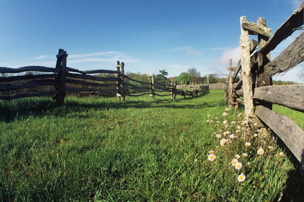
Camp Hensley

The Pixel Team hiked up to Hensley Settlement after the Southeastern Foot Trails Conference and it was a fantastic, sublime experience. Sherman Hensley hiked up this mountain in 1903 with his pregnant wife and all of the tools and livestock they could drive. They saw a large, flat expanse on the mountain summit and carved out a pioneer homestead. Two backcountry camps are within 0.5 miles of this historic community.

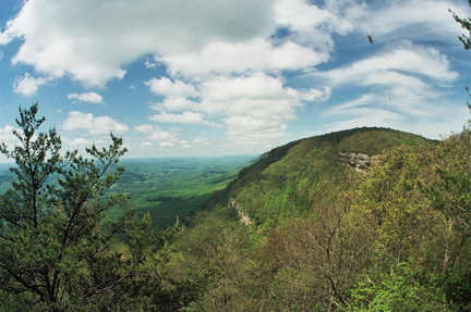
Ridge Trail overlook

[Read more…]

White Rocks and the Ridge Trail

White RocksHiker Hiker Cumberland Gap Map
Distance: 16 Miles round-trip from trailhead
Difficulty: +++
Scenic Views: ++++
Elevation Relief: 1,800ft ^^
Ownership: Cumberland Gap, NPS
Google to trailheads

Cumberland Gap Trail Map: $12

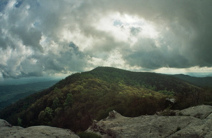
White Rocks Overlook

The White Rocks overlook to Martin’s Fork on the Ridge Trail is the “power-date” of overnight trips in Cumberland Gap. You have a massive ascent, a capital view, and great camp at Martin’s Fork rustic cabin. The stadium rockhouse Sand Cave helps cool your engines and spirit. Trees bent dog-legged by mountain top winds great you like old friends. You are on the Ridge Trail.whiterocks-hike-rgb-web-lar.gif

[Read more…]

Cumberland Gap Trip Planner

Trip Planner Great Backcountry Trips at Cumberland Gap
This webpage with zoomable map shows awesome backcountry trips in color-coded loops, all of which use some segment of the Ridge Trail. Trips are organized as weekend excursions with suggested camping and water access. The map is a simplified version of the full topographic trail guide found here. The full map also contains the useful elevation profiles for trails.

The page also has links to audio about recreation in Cumberland Gap. The audio is part of the free audio driving tour we produced entitled, The First Frontier Audio Driving Tour. The entire tour can be download for free at firstfrontier.org.

Hiker Hiker Cumberland Gap Trail Guide
Ownership: Cumberland Gap National Historical Park, NPS
Google to trailheads

Cumberland Gap Trail Map: $12

Interactive maps: 3D and 2D

Visit the Cumberland Gap trail planner for your next backcountry trip.

Gibson Gap – Ridge Trail – Hensley Settlement

Hensley SettlementHiker Hiker Cumberland Gap Map
Distance: 23 Miles round-trip from Wilderness Road Campground
Difficulty: +++
Scenic Views: ++++
Elevation Relief: 2,100ft ^^^
Ownership: Cumberland Gap, NPS
Google to trailheads

Cumberland Gap Trail Map: $12

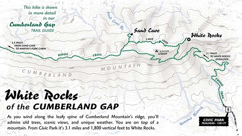
Trails in Hensley settlement

Sherman Hensley hiked up this mountain in 1903 with his pregnant wife and all of the tools and food-on-foot he could drive. They saw the large meadow that would bear the Hensley name and carved out a pioneer homestead. The Gibson family later joined the settlement and together they lived on the mountain, even after the park purchases their land until Sherman left in 1970. [Read more…]

Pine Mountain Trail – Elkhorn City to Skeet Rock

Skegg WallHiker Hiker Pine Mountain Trail Map
Distance: 14 Miles round-trip from trailhead
Difficulty: ++++
Scenic Views: +++
Elevation Relief: 2,100ft ^^^
Ownership: Private, Kentucky SP, Jefferson NF
Google to Elkhorn City trailhead

Free download

The Pine Mountain Trail is one of the most challenging trails in Kentucky. The elevation change, distance, and the undulating, serrated ridge together make a hard, but rewarding backpacking trip. Perhaps the most difficult aspect of the trail are the many intersecting jeep and ohv trails. Even with a good map and navigation tools, you will loose the trail and hopscotch down this trail or that. No worries though, since the trail essentially hugs the knife edge of the ridge, you will eventually, if arduously, retake the trail. [Read more…]

0

Your Cart