

 Cumberland Gap Map
Distance: 16 Miles round-trip from trailhead
Difficulty: +++
Scenic Views: ++++
Elevation Relief: 1,800ft ^^
Ownership: Cumberland Gap, NPS
Google to trailheads
| Cumberland Gap Trail Map: $12 |
 |
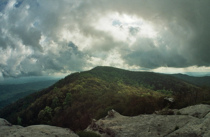 White Rocks Overlook
The White Rocks overlook to Martin’s Fork on the Ridge Trail is the “power-date” of overnight trips in Cumberland Gap. You have a massive ascent, a capital view, and great camp at Martin’s Fork rustic cabin. The stadium rockhouse Sand Cave helps cool your engines and spirit. Trees bent dog-legged by mountain top winds great you like old friends. You are on the Ridge Trail.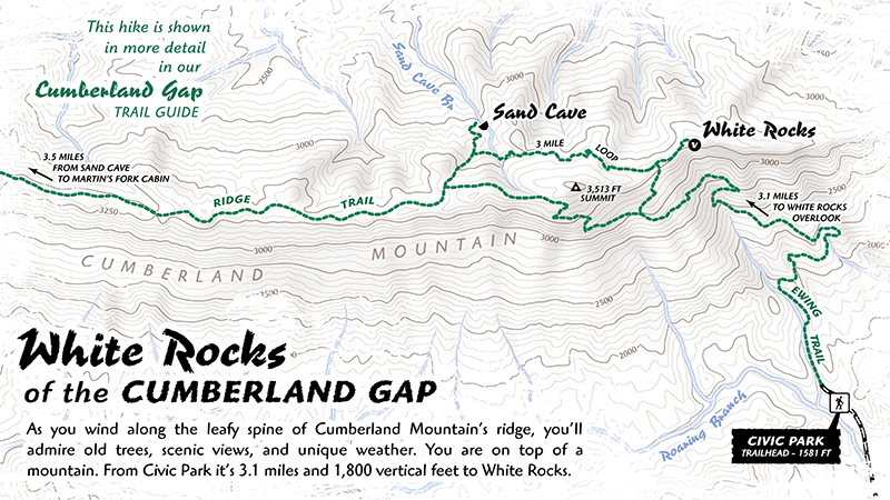
Plans for 2 day, 16 mile backpacking trip with camp at Martin’s Fork campground.
- Start at Civic Park and hike 3.5 miles up Cumberland Mountain (1,800 vertical feet) to White Rocks. The hike is almost continually ascending, but you’ll find rests in a few switchbacks. You’ll catch glimpses of White Rocks high above the trees.
- White Rocks gives the biggest view you’ll have in Kentucky, save Kingdom Come or the Breaks. While most hikers stop at their first view, White Rocks is series of overlooks that rim an extensive outcropping of sandstone.

- Travel west 4 miles, following the south side of Cumberland Mountain, to Martin’s Fork camp, which is nestled in a sheltered valley. You can reserve the cabin, which is a homestead structure moved to this location and has a hearth, 6 bunks, and many mice. Securing your food at night may be wise because of wandering bears, but is necessary to protect your food from marauding mice. The camp also has 5 primitive areas with picnic tables. One issue is securing firewood. The camp is surrounded by dense rhododendrons and has been so thoroughly culled through for firewood, it resembles a park.
- In the morning, enjoy a hearty cup of joe next to the mountain stream tumbling down the valley before the 4 mile hike through Bailes Meadows to visit Sand Cave. Since you have covered the this section the day before, you’ll have spied a couple scenic areas for photography.
- Sand Cave is about a 500ft descent from the Ridge Trail. The cave is really a resort-sized rockhouse with a football field of deep sand.
- Hike 2 miles to White Rocks on the north side of Cumberland Gap around and beneath the highest point. Finally hike 3 miles down the mountain to Civic Park.
Listen to descriptive audio about:
-
- Daniel Boone & the Pinnacle,
9 minutes.
- Daniel Boone & the Pinnacle,
-
- Gap Cave & Hensley Settlement,
8 minutes.
- Gap Cave & Hensley Settlement,
-
- The Tunnel,
4 minutes
- The Tunnel,
-
- Crossing Cumberland Gap,
2 minutes
- Crossing Cumberland Gap,
-
- Impact Crater in Middlesboro,
3 minutes
- Impact Crater in Middlesboro,
*NOTE: audio is part of free driving tour available at firstfrontier.org
Visit the Cumberland Gap trail planner for your next backcountry trip.


Speak Your Mind
You must be logged in to post a comment.