Map Shop
Welcome to your ultimate source for hiking maps in Appalachia! Unfold your next Appalachian adventure with an outrageGIS map for the Red River Gorge, Sheltowee Trace, Cumberland Gap, and more. If you experience an ordering issue or have a question, please don’t hesitate to contact us.
Showing all 15 resultsSorted by latest
-
Sale!

Red River Gorge Topo Map + Trail Tee Gift Pack
Original price was: $50.00.$37.50Current price is: $37.50. Select options This product has multiple variants. The options may be chosen on the product page -
Sale!

Red River Gorge Trail Map Tee
Original price was: $36.00.$30.00Current price is: $30.00. Select options This product has multiple variants. The options may be chosen on the product page -

Red River Gorge Backpacking Map
Price range: $15.50 through $29.00 Select options This product has multiple variants. The options may be chosen on the product page -

Sheltowee Trace North Trail Map
Price range: $15.50 through $29.00 Select options This product has multiple variants. The options may be chosen on the product page -

Sheltowee Trace South Trail Map (Includes Big South Fork)
Price range: $21.25 through $33.00 Select options This product has multiple variants. The options may be chosen on the product page -
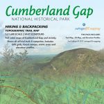
Cumberland Gap National Park Trail Guide
Price range: $12.50 through $23.00 Select options This product has multiple variants. The options may be chosen on the product page -

Great Smoky Mountains GPS and GeoPDF Pack
$20.00 Add to cart -
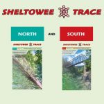
Sheltowee Trace Complete Map Set
$33.00 Add to cart -

Pine Mountain Trail Adventure Guide
View products -

Cumberland Gap National Park Trail Guide (1st Edition)
Price range: $12.00 through $24.00 Select options This product has multiple variants. The options may be chosen on the product page -

Sheltowee Trace GPS Trail and Mile Markers
$10.00 Add to cart -

Cave Run Lake Trail Guide
$14.00 Read more -

Red River Gorge Sports Map
$12.00 Read more -
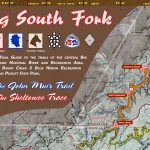
Big South Fork and John Muir Trail Map
$14.00 Read more -

Great Smoky Mountains Trail Atlas
$28.00 Select options This product has multiple variants. The options may be chosen on the product page


