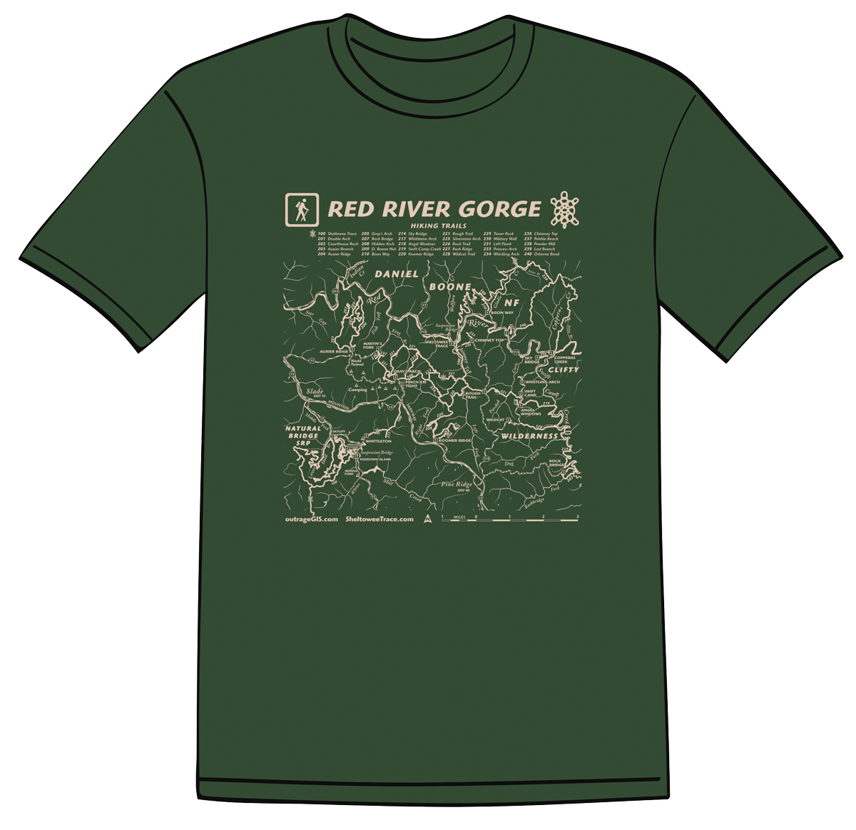
319 Photos

We’re gearing up with a new online #SheltoweeMap with a participatory aspect. Keep tuned and get a map for exploring.

In the meantime, check out some photographs from the Sheltowee Trace from our archive: http://pixel.outragegis.com/main.php?g2_view=keyalbum.KeywordAlbum&g2_keyword=Sheltowee+Trace

and current photos: https://www.flickr.com/photos/28640579@N02/

Woodland Art Fair time, 2014!

Come down to the Woodland Art Fair this Saturday and Sunday, August 16 and 17,and check out our new Sheltowee Trace North map. We have a couple neat projects in the works and would like to hear your trail adventure stories.

Cover wrap of our new Sheltowee Trace Map

Cover wrap of our new Sheltowee Trace Map. Click to enlarge.

[Read more…]

Sheltowee Trace North map

Trails in the northern half of the Daniel Boone

Trails in the northern half of the Daniel Boone

We are now printing the Sheltowee Trace North map, which covers the ST and official trails between the Northern Terminus and Mckee in Jackson County, Kentucky. That’s 138 miles of ST and  130 miles of official trail. The map is same scale as our previous ST south maps, but the sheet size has been enlarged to 19″ x 27″ and packs down to 4.5″ x 6.5″. We will also offer a lamination and heat press service to make these maps bomber in the field.

Cover wrap of our new Sheltowee Trace Map

Cover wrap of our new Sheltowee Trace Map. Click to enlarge.

A couple unique additions to this title might be useful for the serious trail enthusiast. The map is formatted to show the trail network of Cave Run Lake and Red River Gorge on single, separate sheets. The new ST reroute around Morehead and new trails in Cave Run are located. Groceries, public libraries, power lines, and pipelines are located. We’ve added 1,000 m UTM grid. What else? Lots of love and devotion for the trails of the Daniel Boone.

Overview

Low resolutions drafts of the press sheets (note these previews require Flash). These have been altered in final version. The only way to see the finished map is to hold it in your hand!

Northern Terminus
Cave Run Lake
Red River Gorge
Southern Gorge, Turkey Foot, and McKee

Just like the South ST map, when the ST leaves a sheet it has a letter in a red box as label to match the trail on the next sheet. Just follow A…B…C… for 138 miles.

Thanks for the input in correcting thre above drafts!

Working on a Cumberland Falls map

July draft of Cumberland Falls trail map

July draft of Cumberland Falls trail map

This July we have started a topographic trail map for the Cumberland Falls State Resort Park. The map will use aerial photography, 20-foot elevation contours, and GPS mapped trails. This two-sided 13.5″ x 19″ full-color map will show the entire park and connecting trails into the Daniel Boone NF, including Dog Slaughter Falls. This map is at 1:15,000 scale. The second map will zoom into the central area of the park and show trails at 1:5,000 scale. We anticipate this will be an awesome map, especially when used under a moonbow.

Winter into Spring, Kentucky 2014

Winter to Spring in Satellite Images, 2014

Winter to Spring in Satellite Images, 2014

After an unusually long and cold winter, Kentucky has finally emerged to full-blown spring weather. These five images show the clearest, cloud-free day for each month from January 1 to May 5. Snow is clearly seen in the first two months and it’s striking how defined the snow lines are, perhaps 20 miles. You could have heavy snow in Lexington, but snow free in Richmond.

In the January image, we can see the hemlock and pine forest in the Red River Gorge and recently mined ares in eastern Kentucky. In the February image, Cave Run Lake appears frozen.

Another interesting observation is the rate pastures and forests leaf out. Kentucky’s pastures became green in early April, while the forests leaf out by the first days of May.

March is my favorite image. The sun is the highest while the vegetation is at the minimum.  Soon, the explosion of photosynthesis will sweeten the earth with life.

No wildfires are seen (maybe one in April image in eastern Kentucky).

Kentucky transitions into fall

MODIS images of changing seasons in Kentucky, 2013

MODIS images of changing seasons in Kentucky, 2013


These satellite images are from the Moderate Resolution Imaging Spectroradiometer (MODIS) instruments on two satellites, Aqua and Terra. MODIS captures 36 electromagnetic wavelength bands to measure atmospheric water vapor, ozone, aerosols, land fire, surface temperature, and many other important variables of global climate. These images are visible light and clearly show the change in deciduous canopy cover within roughly a month of time. Spatial resolutions are between 250 m to 1 km.

Draft of North Sheltowee Trace Map

Interactive viewer to proof the content of the map.

Interactive viewer to proof the content of the map.

We are sharing our first draft of the Sheltowee Trace North map and we encourage you to proof it and give us feedback. The map covers the ST from the north terminus in Rowan County, Kentucky to DBNF’s Turkey Foot Campground along the banks of the War Fork near McKee, Jackson County.

The print format of this map will be 19″ x 27″ and on two double-sided sheets. The layout format is following: map one is Northern Terminus to Corner Ridge at Mariba; and map two is Corner Ridge to Turkey Foot.

Since the northern half of the ST has more contiguous public land, we went to the big sheet showing larger tracts of area. Trails in the Cave Run Lake and Red River Gorge areas are completely covered; in fact, this map might cover all official trails in the Cumberland Ranger District.

What needs to be done? We still need to add elevation contour labels and Sheltowee Trace mile markers. The south map counts miles from the old southern terminus and is no longer correct. To resolve mile markers on the north map, we’ll start counting from the northern terminus and provide a conversion for north-bound hikers using either the new or old southern terminus. Any suggestions about this mile maker plan?

A few notes about the map viewer. This map viewer is built out of TileMill and should work with most modern browsers, including mobile. As we develop new data about the alignment and distance of the Trace, we can easily update this draft. The images are reduced in resolution and they will appear a little ragged. We’re proofing content, here so please don’t the aesthetics, yet!

NOTE: the interactive works in Firefox, Chrome, Safari, and IE8. You’ll need to run compatibility mode if your browser is IE9 or greater.

Sheltowee Trace Bird’s Eye View Map

Draft of the ST 3D

We have been working on our 3D map of the Sheltowee Trace. This Bird’s Eye View map shows the official forest service trails and recreation areas on a 3D map of the Pottsville Escarpment that separates the rugged Cumberland Plateau with the more rolling Bluegrass and Pennyrile regions.

We encourage you to explore this map give us any feedback. We will probably print portions of the map as insets in the Sheltowee Trace north map on which we are currently working.

Visit the map:
outrageGIS.com/sheltowee/3D

El Niño to make the mountains colder and drier this winter

Predicting climate in the old days relied upon observing cues in nature. The Farmers’ Almanac finds that people looked at woolly worms in late summer in get a sense of winter. The more black hairs on the worm, the colder and wetter the winter. Of course woolly worms come in all configurations of black and orange colorings so how could a worm’s coat predict winter? It can as an analogy;  you look at the forecast to decide which coat you’re going to wear before leaving home. I think you would want to wear a black coat as opposed to a white coat on a very cold and sunny day to maximize the amount of solar energy you could absorb. Woolly worms just plan far ahead.

Today we track global changes in wind patterns and sea surface temperatures to predict weather conditions. NOAA’s Climate Prediction Center has issued a climate forecast for this winter based on the El Niño pattern emerging in the Pacific Ocean.

Below are winter predictions for the U.S. indicating greater or lesser chances for departures in average winter temperatures and precipitation.

temps

precip

El Niño is a departure from average sea surface temperatures created by a change in the intensity and direction of equatorial winds. In a normal period, strong easterly trade winds blow across the Pacific and upwell cold, nutrient rich waters on the west coast of South America. These same winds also pile up water in the western Pacific so that the sea surface is about 2 feet higher at Indonesia than at Ecuador.

Normal Sea Surface Temperatures in °C

In an El Niño cycle, the winds are not as intense and warmer sea surface temperatures extend further to east. This change has a global impact on weather with increased precipitation on the west coast of South America and the south & east coasts of North America. Warmer than normal conditions also occur at higher latitudes in North America and over the Pacific ocean.

El Niño Sea Surface Temperatures in °C

El Niño Sea Surface Temperatures in °C

Sept 12: Sheltowee Trace Meeting in Winchester

The Future of the Trace: Sept 12, 2009

Join a group of trail enthusiasts and forest & park officials at the Daniel Boone NFS headquarters in Winchester to discuss the future of the Sheltowee Trace. We need as many committed folks as possible to attend. Voice your support for the Sheltowee Trace.

If you would like to attend, you can RSVP here with a comment so we can plan for breakfast and lunch!

Time: 9:30am
Where: Clark County Extension Office (map below)
1400 Fortune Dr
Winchester, KY 40391-8292
(859) 744-4682

Preliminary Agenda

9:30 to 10:00 – Meet and Greet – Coffee, Juice and Bagels, Donuts provided.

10:00 Opening Comments

  • Frank Beum, Forest Supervisor, Daniel Boone National Forest
  • Steve Handley, Big South Fork National Recreational Area, National Park Service
  • Carey Tichenor, Ky State Parks and Recreation
  • Steve Barbour, Interim Executive Director, The Sheltowee Trace Association

10:30 – Updates on the Current Condition of The Trace in each Ranger District and Plans for the next 12 to 24 months

10:45 – Current Management Plan Development

  • Federal and State Funding Levels
  • Challenges of a Muti-use Trail
  • Current on-going volunteer programs
  • Short Term and Long Term Maintenance Issues
  • Trace Blazing – Signage
  • Land Acquisition
  • Trace Relocation
  • Maintaining Easements
  • Development of the Volunteer Base
  • Promoting The Trace across the state

Following these discussion will be a session on forming the Sheltowee Trace Association, a non-profit dedicated to promoting and protecting this National Recreation Trail.

Map:Here

Sheltowee Trace Suspension Bridge Quiz

How many scenic suspension bridges exist on the Sheltowee Trace and where are they? If you think you know the answer, then please take our quiz and you might win some free maps.

Directions: If you can name or locate all of the suspension bridges on the Sheltowee Trace, then you can receive our new Sheltowee Trace map for free. Name all of the them and tell us which is the largest and which is the smallest, then you’ll get three free maps of your choice.

How to submit you answer: Email your answer to contest@outrageGIS.com beginning Friday, August 21, 2:00pm EST. You must be the seventh correct email to win. You only get one try and we’ll take your first answer.

If you’re not the 7th person to answer either question correctly, then you will still receive a bonus coupon to use at our online store. Just give it a try!

Ok….which bridge is this? If you need a little help, visit http://www.sheltoweetrace.com

Neck deep in the Sheltowee Trace

Overview map from the Sheltowee Trace South (in development)

After the successful release of our new edition of the Red River Gorge Backpacking Guide last May, we’re now deep into making a comprehensive map of the Sheltowee Trace.

This is our most ambitious mapping and publishing project yet. We’re showing the entire 282 miles of foot, equestrian, and multiuse trail at 1:32,000 scale…that’s 1 inch to a 1/2 mile. So in this publication, you’ll be able to hold the full Trace in your hands…all 12 feet of it.

Let’s think of it a different way. To show this trail adequately, we’re designing and printing over 24 sq. ft. of map at full-color. That’s equivalent to making a 4×6 foot map that labels every stream, destination, and trail. This is a generous allotment of time and paper, but the trail’s incredible beauty and future deserve it. The Sheltowee is Kentucky longest hiking trail and frankly certain parts need to be used more by hikers.

Like our other maps, the Trace map will be a fine navigation tool. We’re dropping in latitude/longitude grids for GPS navigation, mile markers for the Trace that have been meticulously measured, 50-ft topographic elevation contours, canopy cover, and connecting trails and trailheads.

We’ll release the South edition for the Woodland Park Art Fair this August, with the North edition following shortly after. Each edition will have same format: an overview map that gets you to the major trailheads and the topographic trail maps. The image on the left shows a draft of the overview map. To the general layout of the detailed maps, visit here (note these do not show any text yet, just a preview of how we’re gonna make the Sheltowee).

The Trace is a 286-mile National Recreation Trail that connects recreation areas in the Daniel Boone National Forest, Big South Fork, Cumberland Falls, and Natural Bridge State Park.

Rainy May: on track to be the wettest May ever

Spring is typically a wet month. However over the past week, Eastern Kentucky has experienced unusual rainfall amounts. The record for the month is 10.78 inches in 2004; and no other year has been above 10 inches for May. The only year that saw over 9 inches of rainfall for May was in 1995. May during 1983 and 1984 were the only times over 7 inches of rainfall.

From the National Weather Service in Jackson, Kentucky:

"2 TO 5 INCHES OF RAIN HAS FALLEN ACROSS EASTERN KENTUCKY DURING THE
MONTH OF MAY. THIS IS OF INTEREST...SINCE WE ARE ONLY ABOUT ONE
QUARTER OF THE WAY THROUGH THE MONTH. HEAVY RAINFALL IS VERY
POSSIBLE AS WE HEAD INTO MOTHERS DAY WEEKEND AND COULD PUSH RAINFALL
AMOUNTS UP ANOTHER INCH OR TWO.

THE AVERAGE PRECIPITATION FOR THE MONTH OF MAY AT THE JACKSON
WEATHER OFFICE IS 4.92 INCHES. WE HAVE ALL READY RECORDED 4.12
INCHES OF RAINFALL AS OF THIS MORNING AT 7AM. IT IS TOO EARLY TO TELL
...BUT WE ARE CERTAINLY ON TRACK TO HAVE ONE OF THE RAINIEST MAYS
EVER. THE RAINIEST MAY OCCURRED IN 2004 WHEN THE JACKSON WEATHER
OFFICE RECORDED 10.78 INCHES FOR THE MONTH. THIS WAS THE ONLY MONTH
OF MAY THAT OVER TEN INCHES OF RAIN FELL. MAY OF 1995 HAD 9.91
INCHES AND WAS THE ONLY MONTH WITH OVER 9 INCHES RECORDED. THE NEXT
HIGHEST TOTALS WERE OVER 7 INCHES AND THAT OCCURRED IN ONLY TWO
YEARS...1983 AND 1984.

HERE ARE RAINFALL TOTALS FROM EASTERN KENTUCKY COOPERATIVE WEATHER
STATIONS AND AUTOMATED SURFACE OBSERVING SYSTEMS AS OF 7 AM
EDT...FOR THE MONTH OF MAY 2009.

LOCATION         /   COUNTY     /     PRECIPITATION

BARBOURVILLE         KNOX              4.38  INCHES
BAXTER               HARLAN            3.85  INCHES
BEATTYVILLE 4N       LEE               3.68  INCHES
BIG SHELBY           PIKE              3.01  INCHES
BOONEVILLE 1SE       OWSLEY            4.49  INCHES
BUCKHORN LAKE        PERRY             2.80  INCHES
CARR CREEK LAKE      KNOTT             2.73  INCHES
CAVE RUN LAKE        ROWAN             2.28  INCHES
CLAY CITY 1WNW       POWELL            2.77  INCHES
CLOSPLINT 4ESE       HARLAN            4.55  INCHES
COLO                 PULASKI           3.98  INCHES
CRESSY               ESTILL            2.59  INCHES
DRAFFIN              PIKE              3.54  INCHES
EZEL                 MORGAN            3.31  INCHES
GIMLET               ELLIOTT           2.60  INCHES
HARLAN 1S            HARLAN            3.80  INCHES
HARLAN STATE POLICE  HARLAN            2.95  INCHES
HAZARD WATER         PERRY             3.71  INCHES
HAZARD               PERRY             3.70  INCHES
HAZARD STATE POLICE  PERRY             2.95  INCHES
HEIDELBERG 2N        LEE               4.05  INCHES
BAXTER               HARLAN            3.85  INCHES
INEZ 2E              MARTIN            3.78  INCHES
ISLAND CITY          OWSLEY            5.16  INCHES
IVEL                 FLOYD             2.27  INCHES
NWS JACKSON          BREATHITT         4.12  INCHES
JEREMIAH 1S          LETCHER           3.11  INCHES
KINGDOM COME ST PARK HARLAN            3.12  INCHES
LONDON CORBIN APT    LAUREL            4.46  INCHES
MONTICELLO 3NE       WAYNE             4.00  INCHES
MOUNT STERLING 5N    MONTGOMERY        2.41  INCHES
MOUNT VERNON         ROCKCASTLE        2.77  INCHES
ONEIDA               CLAY              4.54  INCHES
PAINTSVILLE 1E       JOHNSON           3.55  INCHES
PIKEVILLE ST POLICE  PIKE              2.05  INCHES
PRESTONSBURG 3NW     FLOYD             4.09  INCHES
QUICKSAND            BREATHITT         3.52  INCHES
RELIEF               MORGAN            3.18  INCHES
ROGERS               WOLFE             2.82  INCHES
SALYERSVILLE         MAGOFFIN          4.28  INCHES
SANDY HOOK           ELLIOTT           2.67  INCHES
SKYLINE              LETCHER           3.20  INCHES
SLADE 5NE            POWELL            2.86  INCHES
SOMERSET 2N          PULASKI           3.74  INCHES
STANTON 2W           POWELL            2.88  INCHES
STEARNS 2S           MCCREARY          5.09  INCHES
VICTORY 5NW          LAUREL            4.13  INCHES
WEST LIBERTY 3NW     MORGAN            2.67  INCHES
WEST LIBERTY 11NW    MORGAN            2.57  INCHES
WHITESBURG           LETCHER           2.50  INCHES
WHITESBURG 2SE       LETCHER           3.21  INCHES
WILLIAMSBURG 1NW     WHITLEY           5.14  INCHES

THE NATIONAL WEATHER SERVICE AT JACKSON WOULD LIKE TO THANK ALL THE
DEDICATED COOPERATIVE WEATHER OBSERVERS FOR THEIR TIMELY REPORTS."

(raw) 3D map of Eastern Kentucky

As we gear up for the Sheltowee Trace topographic map, I thought it would be interesting to see if a complete 3d map of the ST could be printed. Unfortunately, it would have to be a huge sheet of paper to get the detail necessary for a good map. But as an online viewer, I see potential. This sample is a raw render output and you can see well the basic physiography. Now we just need to add trails, transportation, labels, etc….nothing too much, just about 6,000 sq. mi. for the Daniel Boone NF.

3D map
Explore this map through a zoomable flash map

New Red River Gorge Map

5th Edition Red River Gorge5th Edition Red River Gorge Backpacking Map

It’s almost ready for release!
A complete remake of our popular backpacking guide with the green maps. This new set keeps all of the great features of the old maps, but in full-color and updated trails and data.

Visit our Gorge webpage to learn more: http://www.outrageGIS.com/gorge

In January we looked at the previous editions, all 2-color with an travel elevation profile booklet, and thought how we could improve it. We had used aerial photography to show landcover type, which did a good job indicating density of canopy, open areas, sunlight, and offered a rustic green background for our GPS trails.

However, most people are confused when they look at aerial photographs…they think hills are valleys and vice versa. This terrain inversion is a significant cartographic problem, but we were confident then when most people *used them in the field* they made sense.

While unique advantages exist using photographs, for the new edition we used a custom created, full-color hillshade that shows forest canopy cover type and open areas. We artificially lit the landscape from the west and eliminated terrain inversion. We added a distinct stream symbol to clearly mark drainage. With 50-foot contours and spot elevations, this new edition offers a handsome way to stay located.Gray's Arch rockshelter

Since most GPS applications are now by default in the latitude/longitude (decimal degrees) coordinate system, we added this graticule to the map. A UTM grid is also labeled. With scales on the corners of maps that can be seen while folded, a hiker can quickly determine distance and locate themselves with a GPS in either dd.dddd or UTM coordinate systems.

We still have all of the trail profiles, side trails, backcountry campsites that were in the previous edition. The new edition actually covers more area and trails.

Red River Gorge Backpacking Map: $14
0

Your Cart