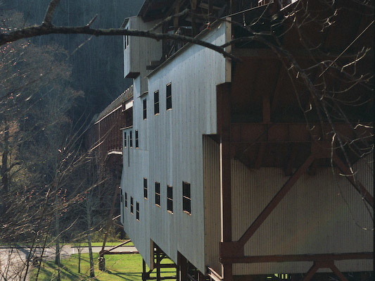
Blue Heron tipple as preserved in the NPS outdoor museum.
This area is covered in our Big South Fork Trail Map:
[img]http://www.outragegis.com/store/images/T/th_BISO_Cover-125w.jpg[/img]
Buy this map
Blue Heron tipple as preserved in the NPS outdoor museum. This area is covered in our Big South Fork Trail Map: [img]http://www.outragegis.com/store/images/T/th_BISO_Cover-125w.jpg[/img] Buy this map

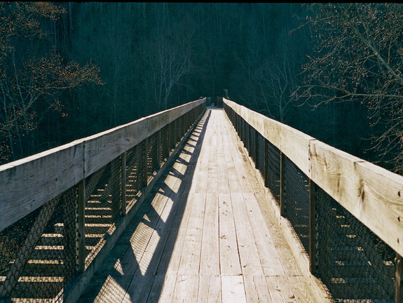
Bridge over Big South Fork connecting the Blue Heron Loop with the Kentucky Trail.
This area is covered in our Big South Fork Trail Map:
[img]http://www.outragegis.com/store/images/T/th_BISO_Cover-125w.jpg[/img]
Buy this map
Bridge over Big South Fork connecting the Blue Heron Loop with the Kentucky Trail. This area is covered in our Big South Fork Trail Map: [img]http://www.outragegis.com/store/images/T/th_BISO_Cover-125w.jpg[/img] Buy this map

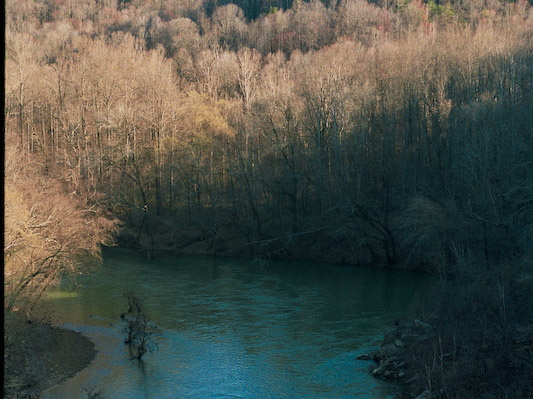
View east from bridge over Big South Fork.
This area is covered in our Big South Fork Trail Map:
[img]http://www.outragegis.com/store/images/T/th_BISO_Cover-125w.jpg[/img]
Buy this map
View east from bridge over Big South Fork. This area is covered in our Big South Fork Trail Map: [img]http://www.outragegis.com/store/images/T/th_BISO_Cover-125w.jpg[/img] Buy this map
![Trail near Devil's Jump (2619 visits)
This area is covered in our Big South Fork Trail Map:
[img]http://www.outragegis.com/store/imag... Trail near Devil's Jump](_data/i/galleries/090320_BSF-BlueHeron/14A_0352-cu_e576x432.jpg)
This area is covered in our Big South Fork Trail Map:
[img]http://www.outragegis.com/store/images/T/th_BISO_Cover-125w.jpg[/img]
Buy this map
This area is covered in our Big South Fork Trail Map: [img]http://www.outragegis.com/store/images/T/th_BISO_Cover-125w.jpg[/img] Buy this map
![Eroded Sandstone (2609 visits)
This area is covered in our Big South Fork Trail Map:
[img]http://www.outragegis.com/store/imag... Eroded Sandstone](_data/i/galleries/090320_BSF-BlueHeron/14A_0377-cu_e576x432.jpg)
This area is covered in our Big South Fork Trail Map:
[img]http://www.outragegis.com/store/images/T/th_BISO_Cover-125w.jpg[/img]
Buy this map
This area is covered in our Big South Fork Trail Map: [img]http://www.outragegis.com/store/images/T/th_BISO_Cover-125w.jpg[/img] Buy this map
![Devil's Jump rapids (2725 visits)
This area is covered in our Big South Fork Trail Map:
[img]http://www.outragegis.com/store/imag... Devil's Jump rapids](_data/i/galleries/090320_BSF-BlueHeron/15A_0353-cu_e576x432.jpg)
This area is covered in our Big South Fork Trail Map:
[img]http://www.outragegis.com/store/images/T/th_BISO_Cover-125w.jpg[/img]
Buy this map
This area is covered in our Big South Fork Trail Map: [img]http://www.outragegis.com/store/images/T/th_BISO_Cover-125w.jpg[/img] Buy this map
![Pixel and Salley on stair ladder (2644 visits)
This area is covered in our Big South Fork Trail Map:
[img]http://www.outragegis.com/store/imag... Pixel and Salley on stair ladder](_data/i/galleries/090320_BSF-BlueHeron/15A_0378-cu_e576x432.jpg)
This area is covered in our Big South Fork Trail Map:
[img]http://www.outragegis.com/store/images/T/th_BISO_Cover-125w.jpg[/img]
Buy this map
This area is covered in our Big South Fork Trail Map: [img]http://www.outragegis.com/store/images/T/th_BISO_Cover-125w.jpg[/img] Buy this map
![Kentucky Trail (2610 visits)
This area is covered in our Big South Fork Trail Map:
[img]http://www.outragegis.com/store/imag... Kentucky Trail](_data/i/galleries/090320_BSF-BlueHeron/16A_0379-cu_e576x432.jpg)
This area is covered in our Big South Fork Trail Map:
[img]http://www.outragegis.com/store/images/T/th_BISO_Cover-125w.jpg[/img]
Buy this map
This area is covered in our Big South Fork Trail Map: [img]http://www.outragegis.com/store/images/T/th_BISO_Cover-125w.jpg[/img] Buy this map
![Blue Heron Tipple (2522 visits)
This area is covered in our Big South Fork Trail Map:
[img]http://www.outragegis.com/store/imag... Blue Heron Tipple](_data/i/galleries/090320_BSF-BlueHeron/17A_0355-cu_e576x432.jpg)
This area is covered in our Big South Fork Trail Map:
[img]http://www.outragegis.com/store/images/T/th_BISO_Cover-125w.jpg[/img]
Buy this map
This area is covered in our Big South Fork Trail Map: [img]http://www.outragegis.com/store/images/T/th_BISO_Cover-125w.jpg[/img] Buy this map
![Dick's Gap Overlook (2843 visits)
This area is covered in our Big South Fork Trail Map:
[img]http://www.outragegis.com/store/imag... Dick's Gap Overlook](_data/i/galleries/090320_BSF-BlueHeron/18A_0381-cu_e576x432.jpg)
This area is covered in our Big South Fork Trail Map:
[img]http://www.outragegis.com/store/images/T/th_BISO_Cover-125w.jpg[/img]
Buy this map
This area is covered in our Big South Fork Trail Map: [img]http://www.outragegis.com/store/images/T/th_BISO_Cover-125w.jpg[/img] Buy this map
![Big South Fork River (2555 visits)
This area is covered in our Big South Fork Trail Map:
[img]http://www.outragegis.com/store/imag... Big South Fork River](_data/i/galleries/090320_BSF-BlueHeron/19A_0357-cu_e576x432.jpg)
This area is covered in our Big South Fork Trail Map:
[img]http://www.outragegis.com/store/images/T/th_BISO_Cover-125w.jpg[/img]
Buy this map
This area is covered in our Big South Fork Trail Map: [img]http://www.outragegis.com/store/images/T/th_BISO_Cover-125w.jpg[/img] Buy this map
![Kentucky Trail (2528 visits)
This area is covered in our Big South Fork Trail Map:
[img]http://www.outragegis.com/store/imag... Kentucky Trail](_data/i/galleries/090320_BSF-BlueHeron/19A_0382-cu_e576x432.jpg)
This area is covered in our Big South Fork Trail Map:
[img]http://www.outragegis.com/store/images/T/th_BISO_Cover-125w.jpg[/img]
Buy this map
This area is covered in our Big South Fork Trail Map: [img]http://www.outragegis.com/store/images/T/th_BISO_Cover-125w.jpg[/img] Buy this map
![Dick's Gap Overlook (2561 visits)
This area is covered in our Big South Fork Trail Map:
[img]http://www.outragegis.com/store/imag... Dick's Gap Overlook](_data/i/galleries/090320_BSF-BlueHeron/20A_0358-cu_e576x432.jpg)
This area is covered in our Big South Fork Trail Map:
[img]http://www.outragegis.com/store/images/T/th_BISO_Cover-125w.jpg[/img]
Buy this map
This area is covered in our Big South Fork Trail Map: [img]http://www.outragegis.com/store/images/T/th_BISO_Cover-125w.jpg[/img] Buy this map
![Salley on the Kentucky Trail (2552 visits) This area is covered in our Big South Fork Trail Map:
[img]http://www.outragegis.com/store/images... Salley on the Kentucky Trail](_data/i/galleries/090320_BSF-BlueHeron/21A_0384-cu_e576x432.jpg)
This area is covered in our Big South Fork Trail Map:
[img]http://www.outragegis.com/store/images/T/th_BISO_Cover-125w.jpg[/img]
Buy this map
This area is covered in our Big South Fork Trail Map: [img]http://www.outragegis.com/store/images/T/th_BISO_Cover-125w.jpg[/img] Buy this map
![Catawba Overlook (2555 visits) This area is covered in our Big South Fork Trail Map:
[img]http://www.outragegis.com/store/images... Catawba Overlook](_data/i/galleries/090320_BSF-BlueHeron/23A_0361-cu_e576x432.jpg)